One of the neat things about my Mother is that she’s always up for an adventure. Start the car up and she’s ready to go ambling and ramblin. Some days we just head out and see if we can find a road we haven’t explored.
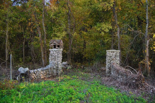
This time we cruised by Cape Rock, then made a left turn onto Big Bend Road just west of East Cape Rock, where I saw the remnants of what our family had always called the Home of the Birds.
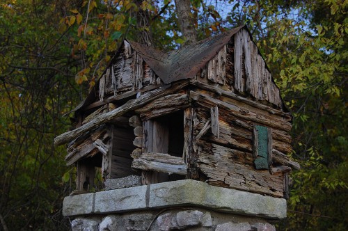
 When I was a kid, there were two bird houses on the stone gate posts, but one of them is long gone and the other doesn’t look long for the world. Of course, they’ve been up there half a century (unless someone has replaced them since I was in my pre-teens), so the survivor may outlast me.
Out of the Past didn’t help
I have to admit that I cheat when it comes to doing research. My first stop is The Southeast Missourian for local factoids. This time, though, when I searched for “Home of the Birds,” I got less than a handful of hits and they were mostly in the Out of the Past column compiled by librarian Sharon Sanders. They just kept referring to Southeast Missouri State University construction projects that were eating up the land “north of the campus.”
What made it worse was that I couldn’t exactly figure out WHERE I had taken the picture so I could put it on the map. I thought I had set a GPS waypoint, but I must not have saved it. Even more confusing was that where I thought I was didn’t seem to be anywhere close to the University.
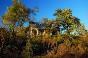
This house picture didn’t help much, either
 I took a picture of this house diagonally across the street from the birdhouse, so I pulled up Google Earth and tried to find IT with no better results.
I learned a long time ago that you don’t have to know everything in the world. You just have to know the people you can call who DO know everything in the world.
I took a stab and sent the pictures in an email to Sharon and to James Baughn, who does a great blog called Pavement Ends, which explores lots of neat areas in Swampeast Missouri. James also has a site, BridgeHunter.com which is a database of historic and notable bridges in the United States. (Full disclosure: I have contributed some bridges to the database and I can get lost in there for hours.)
I’ve never met either person, but I got my first response 21 minutes after the original query. That’s fast. NOT only were they fast, but they were kind enough not to use the phrase, “you fool,” when they pointed out that I wasn’t AT the Home of the Birds.
Springdale Bird Sanctuary
 Sharon’s first message said, “Hi, Ken. I enjoy reading your Central High reminiscences, even though I’m an alum of Notre Dame (class of 79). The photos you’ve taken, I believe, are of the entrance to the Springdale Bird Sanctuary. Let me do some checking and I’ll get back to you.”
James had slightly different info, but he had the GPS coordinates: “This is the old entrance to the Kelso Bird Sanctuary on Highway 177 north of town. The GPS coordinates are 37.341008, -89.501195 — give or take a few hundred feet.”
When I plugged in the coordinates, BINGO! The place was exactly where I thought it would be. But what’s this business about different names?
It’s now called the Kelso Sanctuary Natural Area
Sharon’s next message cleared it up. “Here is the URL for the Kelso Wildlife Sanctuary. At one time, part of the area went by the name Springdale Bird Sanctuary. Hope this helps.”
There’s not a lot of information on line about the the site, but SEMO does have some promotional pamphlets put out by the Audubon Society of Missouri around 1937 after Judge and Mrs. I.R. Kelso donated 20 acres of land for the sanctuary. The Audubon Society transferred management of the land to SEMO in 1960. I’ll have to visit SEMO someday to read the rest of the story.
The sad thing is I STILL don’t know anything about the Home of the Birds.
Kelso Sanctuary Natural Area
View Kelso Sanctuary Natural Area in a larger map

Sharon Sanders continues to be a great resource. Here’s here latest update:
Ken, I took the liberty of asking a genealogy friend of mine (and also a biology professor at Southeast), Bill Eddleman, for information on your photographs. Below is part of his reply.
The Home of the Birds was a grove of trees and tangled brush that used to be where Towers residence halls are today. I have heard my parents (who both attended College High School in the 1940s) refer to this often.
The photos are of the original entrance to I. R. Kelso Wildlife Sanctuary. Springdale Bird Sanctuary began when Judge and Mrs. I. R. Kelso donated 20 acres to the Audubon Society of Missouri in June 1937. Soon after, an additional 7 acres was added. Undoubtedly the late Dr. Homer Bolen, long-time treasurer of the Audubon Society of Missouri, had something to do with the donation.
Since 1962, Southeast Missouri State has leased this portion from the Audubon Society of Missouri for $1 per year. The original donation from Judge Kelso is on the other side of the creek from this entrance, and included the ridgetop and a pond on the other side of the ridge. A subsequent donation by the Kelso heirs (30 acres in 1964), and a purchase of 76-acre Springdale Farm in 1979 (using federal grant dollars and a donation) from the Kelso heirs expanded the University’s part of the sanctuary to its present extent.
At some point in the 1960s or 1970s, the name was changed to I. R. Kelso Wildlife Sanctuary. It is bordered on the east by the 8-acre Juden Creek Conservation Area, and some 30-40 acres comprising Twin Trees Park (city park).
The original entrance has a checkered history. At least three bridges over Juden Creek were washed out during Mississippi River floods (backwater). In the 1980s the University gave up on a bridge, and there was a foot-crossing of concrete-filled barrels and a handline until 1995. This washed out in the that year’s flooding, and users of the site now use the Twin Trees Park/Juden Creek entrance on the east side. It connects to the ridgetop trail.
I am not sure when the entryway was constructed, but Judge Kelso built a similar stone structure along Old Sprigg Street Road at the entrance to his property at some point in the past. I remember the small log cabins from my childhood, and am amazed that one is still there (even if deteriorated). The recent clearing along the electrical wires by AmerenUE has exposed them to public view again.
Great article, thank you for writing about this. You have a lot of educational articles here, thanks again! I really enjoy this hobby, my wife and I have been participating in it for a few years. We are contemplating purchasing a Magellan RoadMate for our vehicle. Do you have any experience with this unit? Click here if you’d like to check out my site. Thanks again for a very educational site!
I use the Garmin Nuvi 760 in my car.
http://www.palmbeachbiketours.com/garmin-nuvi-760-gps/
I signed up for the lifetime map subscription, which pays for itself in a couple of years.
http://www.palmbeachbiketours.com/garmin-gps-numaps-lifetime-subscription/ On top of that, dropping my family AAA membership has saved me enough money that I could buy a new GPS about every three years if I wanted to. About all I ever used was their maps.
I use a Garmin 60CS on the bike. It replaced a Garmin Legend.
I’ve been tempted to try geocaching, but never followed through. I thought about looking for a cache that was hidden at Fort Defiance, at the confluence of the Ohio and Mississippi Rivers in Cairo, but it was under about eight feet of water on that trip through.
Great stuff from you, man. Ive read your stuff before and youre just too awesome. I love what youve got here, love what youre saying and the way you say it. You manage to keep it smart. I cant wait to read more from you. This is really a great post.
In the mid/late 60s a lot of people rode their motorcycles in this place. There was a pretty good trail to ride on and if you were lucky you didn’t get caught.
I used to hike in to fish (and sometimes swim) in the pond on the other side of the ridge. There was a (very) small island in the pond which you can almost see in the satellite picture.