 Fruitland’s Strack Quarry is back in the news again. I’m not even going to try to figure out what the latest wrangle is all about. I’ll let you go to Keith Lewis‘ story in The Missourian to try to figure out how a quarry that had approval to operate and which has moved a bunch of overburden and started poking a big hole in the ground can be told to put the brakes on.
When I was home last summer, I climbed a berm in on the south side of the Saxony Lutheran High School and shot a 360-degree panorama with the school behind me and a graveled area that is on the quarry property in front of me. I’ve marked the photo with compass directions to make it a little clearer. Click on the photo to make it larger.
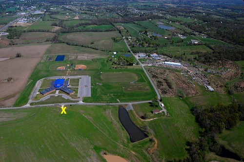
Aerial looking north
 I took this aerial photo April 17, 2011. The quarry property would be at the bottom of the picture.The yellow X marks the approximate place I was standing when I took the panorama. Highway 61 is at the top left. The Y-shaped building near the center of the photo is the high school.
Google Map shows scope of work
View Larger Map
This Google Map will give you an idea of how much land has been cleared for the project. If I’m reading the latest ruling correctly, the pit itself is outside the 1,000-foot latest requirement, but the latest interpretation would require the whole operation to be 1,000 feet away, even though the north end of the property alongside CR 601 is behind a berm that is as high as the rooftop of the school.
Area quarry stories
- Other aerial photos of the site taken in 2011.
- Aerial photos of Strack quarry on Hwy 74
- Which came first: Dalhousie or Strack Quarry on Hwy 74?
- Bulldozer goes over edge at Delta quarry
- Trail of Tears quarry rescue
- Cement plant quarry fills with water
- Cement plant quarry caves
- Tower Rock quarry exposed by low water

Ken, Your pictures are excellent as usual and help explain the whole situation better.
I think we were confusing the “Property Line” with the “Mining boundary line” – which needs to be 1000 feet away. The only problem was that the mining companies original application didn’t indicate how far away their mining boundary would be. The Land Commission approved their application anyway BUT added the “provision” that the mining operation be at least 1000 ft away.
Judge Syler’s ruling simply stated that the Land Commission didn’t have the authority to add provisions – that is the sole right of the legislature.
So this is merely a setback because the mining company can refile a new application that is worded correctly and by existing state statutes it should be approved. That is why they are continuing work to prepare the site as if nothing has happened. They just can’t start “mining” until their new application is approved by the Land Commission.
Of course, that is just my opinion and I’m usually wrong.
Brad
That’s pretty much how I read the decision, too. Frankly, if I was Strack, I’d say, “OK, I’ll move the whole operation back 1000 feet. That’ll give me plenty of room for a pig farm.”
Since the good folks in Fruitland were so opposed to zoning, I don’t see where that would be any problem.
The Quarry in the Google view that is across the County road from the High School is not the Strack Quarry. This Quarry is being developed by Dan Dumey and a few others. The Strack Quarry is being developed as you scrool North, just North of the Rhodes Station.
I’m certainly open to being corrected, but everything I’ve found on line makes it look like the Strack Quarry is south of the school. If the school doesn’t have an issue with the one directly south of it, what is their beef with the one north of Rhodes? I’ve seen the fill being dumped there, but I assumed it was overburden from the dig to the south.
I’ll concede that the drawing at the top of this post would support your contention, but now the school’s opposition makes absolutely NO sense to me.
I’d like someone else to weigh in here before I go through and do a bunch of corrections and updates.
I’m with Vince Kelley that the Strack Quarry is north of the school. J.W. Strack’s property is entered by turning off Highway 61 near the Rhodes Station. The quarry to the south of the school is owned by someone els.
I live in the Fruitland area now and I have to agree with Vince and Larry. They have recently erected a sign reading Strack Quarry at the front of the property off Hwy 61 north of the school.