When you grow up in a Mississippi River town like Cape Girardeau, you learn to rattle off flood stages and historical floods like other kids can name cars as they drive by.
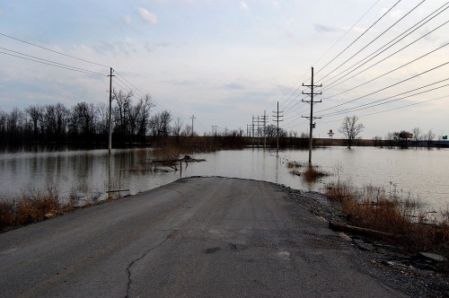
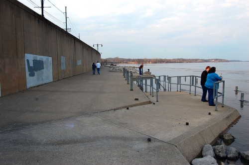
This is Old Highway 61 just south of Cape. Before Interstate 55 was built, this was the main road to Memphis and New Orleans to the south and St. Louis and Chicago to the north.
July 5, 1947, the river hit 41.88 feet, its third highest stage in history up to that point. Highway 61 and Highway 25 went under water, halting car, bus and truck traffic north and south except by taking a circuitous route.
This flooded stretch of Old Highway 61 reaches a dead end at the Diversion Channel. The waters are an inconvenience only to fishermen who would normally launch their boats at a ramp at the end of the road. The Diversion Channel is a drainage ditch that was greatly responsible for changing Swampeast Missouri into valuable farm land. When the Mississippi is high, the river backs up the channel, flooding homes and acres and acres of crops.
1947 was a piker
Time goes by so quickly. It seems like we’ve just had one 500-year flood when another one comes right along. These days, the 1947 flood barely beats a 2008 flood to hang on to ninth place.
Here are the top five crests
- 48.49 ft on 08/08/1993
- 47.00 ft on 05/24/1995
- 46.90 ft on 08/03/1993
- 45.70 ft on 05/18/2002
- 45.50 ft on 05/01/1973
Those numbers have special significance for the Steinhoff family. We have property in Dutchtown that goes under water when the Cape river gauge reads 39 feet. Want to see what 48.49 feet, give or take, looks like when you get wet at 39?
Inside the mechanic shed in 1993
Before my Dad got out of the construction business, this was a large shed used for carpentry and heavy equipment repair. We never dreamed that the water would come up so high and so fast, so we lost some shop equipment and a heavy-duty air compressor. Flooding has become so common that everything of value has been placed high enough that we hope it’ll stay dry for the next 500-year flood.
My brother Mark looks a little uncomfortable because I pointed out to him that flooding brings out snakes, who are looking for higher ground. “We sure look like higher ground to me,” I said.
Why are there more floods?
Man has tried to control the river. It’s been dammed, channelized and confined to a narrower and narrower path than in the days when it could spread out over miles of flood plain. When water can’t spread out, it has no choice but to go up.
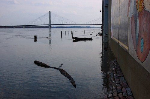
Water’s already lapping at the base of the floodwall at the Themis St. flood gates. When the river gets a couple feet higher, the Broadway gates will close an the city will be sealed off.
Storytelling on the riverfront
A steady stream of visitors come down to watch the muddy waters swirl by every day, but their numbers swell when the river’s on the rise.
I overheard a couple of women wonder what a hole in the wharf was for. (It’s a pipe that would normally have a handrail attached to it, but it had been removed, probably to keep from catching debris.)
I couldn’t help but tell them “that’s where you put in a quarter to keep the river flowing. It’s coin operated. There are locks up the river that open up when the meter is fed. You were lucky to come along after someone else dropped a coin in the slot. It’ll turn off any minute.”
“Really?” one of them asked.
By the way, if that kind of fibbing appeals to you, you should show up for the Storytelling Festival April 9-11. It ain’t lying if you call it storytelling. And can keep a straight face.
Map showing Old U.S. 61 & Dutchtown
View Old U.S. 61 and Dutchtown in a larger map

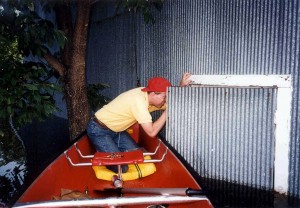
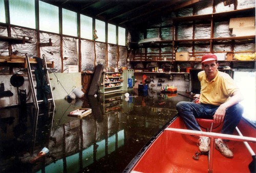
You read my face correctly. I was thinking at the time the bad thing about being in a canoe is there is a limited amount of space to begin with, add the unstable part of a canoe rocking in the water with one agitated snake trying to climb up the sides inside of a canoe and you are suddenly in a rodeo. Plus, which one of us would end up hitting the snake with our paddle putting a hole in the bottom of the canoe in the feverish attempt to liberate the snake with the result of ALL THREE of us in the deep oily water from which the snake had come out of…
So, does the old 61 go down below 55? That’s where you’ve put a blue bubble – right?
What is that abandoned – or nearly abandoned (I think maintenance crews use it)- strip of road that goes south from 74 -where the old metal bridge spans some sort of creek system. Coming to Cape on 74 from Dutchtown, you go under 55, turn north (left) and take that convoluted route to get on 55. If you were to turn south (right), you would cross that old bridge. There’s a big power system at that location, and I’ve seen trucks use the old road to reach the station. I’ve been tempted to drive over the bridge to satisfy my curiosity, but I’m not sure what I would get into!
Madeline,
That’s the road. You’ll cross two bridges: one is a railroad bridge and the other is a small creek. As you go southbound, you’ll see the electrical substation on your left. It’s been heavily diked after it was almost underwater in 1993. The city has some wellfields in the area, too.
When you go a south another half mile or so, you’ll cross another small bridge. I worked a particularly tragic car accident there in 66 or 67. A father took his son out to practice driving. They made a turn onto that bridge (or one similar to it) and the son overcorrected and the car went partially off the bridge. His father opened the door and was stepping out when his weight caused the balance to shift and the car fell off the bridge, pinning him under it and between the door and the car body. Or, at least, that’s the way I remember it.
The road hooks to the right and ends up at the Diversion Channel at a rather nice boat ramp with ample parking.
Go for it, particularly before mosquito season starts. (Well, wait for the water to go down.) The road’s a little bumpy, but it’s safe to drive on.
I have not-so fond memories of flooding near Dutchtown. My grandmother lived near Greenbriar, between Advance and Marble Hill. The quickest way there through Dutchtown, Blomeyer, and Delta. In flood times (every spring?) the trip was rerouted through Jackson and the exciting twin cities of Lutesville-Marble Hill. This nearly doubled the travel time.
If you follow the link to The Missourian story, you’ll find that’s the route the buses took. We forget how important buses and trains were in those days until you read some of those old papers.
Although I can’t remember the year, I do recall my parents taking me downtown to see Main Street flooded and all the sandbagging. Most vivid is the picture of the Montgomery Ward store surrounded by water. And, forever and a day, the distinct scent of the river in the downtown area and businesses remains.
Oh yes, the flooding was always worth at least an annual conversation!
I can recall shopping when the basement floors of the stores were flooded and they’d put down planks leading into the stores so you could shop upstairs.
Dad has a bunch of photos the flooded downtown I’m going to publish when I get around to scanning all of them.
You’re right about the smell, although you have to admit that it got better when St. Louis started treating its sewage instead of dumping it raw. Gas station restrooms used to have graffiti that said, “Flush twice. Cape needs the water.”
I CAN REMEMBER SOMETIME IN THE EARLY TO MID 40’S SHOPPING AT MONTGOMERY WARDS. THERE WERE BOARD SIDEWALKS BUILT INSIDE THE STORE TO WALK ON. OF COURSE, THERE WERE LOTS OF SALES ON MERCHANDISE THAT WAS DRY TO SLIGHTLY WET. A LOT OF IT HAD BEEN CARRIED UPSTAIRS. I CAN IMAGINE THE MESS THAT WAS LEFT AFTER THE WATER RECEDED.
Ah, yes, the sweet smell of FLOOD! I don’t think I’ll ever forget it. We always went down Main Street as far as we could get on the sidewalks and boardwalks built over the water. What entertainment!
I remember riding in a motor boat around downtown as far as Spanish Street. That was in the early 50’s. Ken, I loved your story to the ladies at the river!!
I lived in the 1200 block of North Main Street. My grandfather owned a grocery store next door to his house, Cole and Webb Grocery Store. The water never got in the 1000, 1100 or 1200 block of Main until the Flood Wall was built. After the wall was built, water got in the front yard to the houses south of us and all of Water Street, but never in our yard. The city bought out the homes on Water and Main Streets. However, 2 houses still remain in the 1200 block of Main. The one on the east side of the street is the Deboe house and the one on the west belonged to the Griffith family. There were a lot of awesome memories growing up in Red Star and going to Washington Grade School.
Karen,
If the floodwall was built, where did the water come from? Was it seep water that was trapped?
The Red Star district is outside the wall. That’s why the water got into their yards/houses after the wall was built.
I forgot to mention, after the flood wall was built to protect down town, I remember riding in a small boat to get to Montgomery Ward. My mother and aunt worked there and I got to go with them on one or two occasions. Everything on the first floor had to be moved to the second or third floors. Clothing and appliances were on the first floor. They would have to put to flooring down after the floods when there was damage.