Second Christmas Shopper Mystery Solved

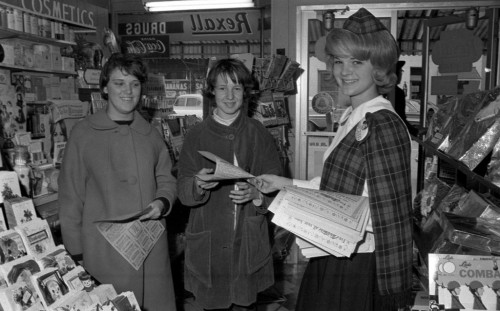
Rexall Drugs in Jackson, MOI posted a gallery of photos of Christmas shoppers last week that set off a scavenger hunt to figure out where they were taken. You can read about the search and eventual outcome here.

They cleared up where Santa was, but how about the other stores?

Missourian photographer Fred Lynch rode to the rescue here, too.

Here’s Fred’s account:

Ken’s pictures of Christmas shoppers inside a Rexall drug store were taken in Jackson. Not Cape Girardeau.

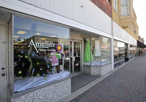
Old Jackson Rexall Drugs

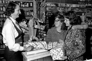
Anita Schulte, left, in Rexall Drugs Store in Jackson, MO, in the mid-60s.Fred asked Cathy Hancock at The Southeast Missourian’s Jackson office to take a look at Ken’s Rexall photos on his blog.

Cathy said: “I believe the drug store shot is Jackson Rexall Drugs, owned by John & Anita Schulte. Anita is the lady behind the counter. It was on High Street uptown and there was a Kroger store across the street, hence the bananas sign.”

Cathy is mostly correct

Fred walked inside the store Cathy remembered and was told that indeed it used to be a drug store. Now it is Amelia’s Fashion Exchange.

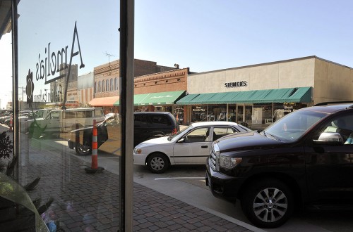
He called Cathy’s neighbor, who worked uptown before retiring, and learned that the grocery store was the A&P rather than Kroger. The A&P was located in what is now Siemer’s Best Brands Plus, an appliance store. He also confirmed the Jackson Rexall Drugs. So imagine looking through Amelia’s window and across the street in the window of Siemer’s is a sign for bananas.

By the way, Kroger was down the block from Rexall at the time.

Old A&P grocery store in Jackson

Jim Vangilder provides more info

Jim Vangilder: These photos were taken in Jackson.  The drug store was Kistner’s Rexall Drug.   The A&P Grocery store was across the street.  The Santa and package wrappers were in Priest’s Department Store.  The photo with the china and glassware was Cox’s Variety Store.

Lynch Finds Santa – in JACKSON

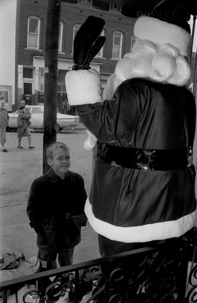
Shopper eyes Santa Claus in Cape Girardeau (actually Jackson)Hillary wrote that it takes a village. She got that right. It took a village of CHS readers to find a town – Jackson.

To recap: I posted a gallery of Christmas shopping pictures on Wednesday and confessed that I didn’t know where they were taken. Since one of them showed the inside of a Rexall Drugs store, I jumped to the conclusion that it had to be Unnerstall’s on Good Hope and that Santa would be nearby.

Santa drew guesses

My brother, Mark, missed the target completely. He thought it was taken from Shivelbine’s on Broadway.

Missourian photographer Fred Lynch keyed in on the telephone pole in the picture and convinced himself (and me) that it was taken on Good Hope near my original guess.

He sent me pictures that seemed to confirm it and I posted an update here. He followed it up with some pictures later taken from almost the same angle as mine that sure made it look like we had found the correct spot.
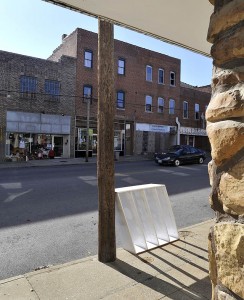
Fred Lynch Haarig photo looking southBill Hopkins chimes in

Emails with pictures attached start flowing in from Bill Hopkins, none of which are even close.

Blitstein sees problem

Chuck Blitstein posted a great description of Good Hope from the days when he worked at Cape Cut rate, but then he questioned our findings:

The location of your Santa photo presents a real conundrum, and the several ‘clues’ exacerbate the problem rather than lead to its resolve; e.g., the shoes in the window tend to make one think of a Men’s Clothing Store; in the 60s the shopping areas were Main Street, Broadway and Good Hope.  Sides-Miller was in the 600 block of Broadway, Irvin’s and Ross Young were on Main but I do not remember a cafe/bar across from them.  Al’s Mid-Town Lounge at 627 Good Hope might  have had a Stag Beer sign, but the word Cafe doesn’t seem to fit and the location seems wrong for the picture.  Hirsch’s might have sold shoes but again, the cafe/bar across the street?  Then, there is the car, ’62 Dodge Dart?  It looks like it is parked at an angle?  I thought all on-street parking was parallel, but maybe not.  Oh, well, a senior moment, I guess.

Hopkins questions Lynch
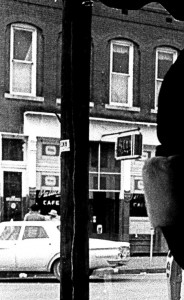
Building across the street closeupBill Hopkins: Fred, take a look at the door in the Santa photo; it has a transom (is that the correct term?) above it and then a window offset slightly to the viewer’s right. In the photo of the building you propose as the correct one, that door (if it’s the same door) does not have such a window above it. In fact, the building you took a photo of shows those star thingies; they were connected to rods and helped support the building. My deceased pal Floyd Runnels (father of Jeanie Runnels Eddleman, the artist who draws historical buildings) was a bricklayer and explained that to me once. Of course I don’t remember what he said.

One more thing I noticed: the Santa building has drainage over the top windows; the suspect building does not.

Larry Saddler agrees with Blitstein

Larry Sadler: Chuck Blitstein points out that the car looks like it is angle parked.  I agree with him.  The sign on the window looks like it says Palace Cafe to me.  I don’t remember the Palace Cafe in Cape Girardeau.  Could this possibly be a picture taken in Jackson.  I believe they used angle parking extensively in Jackson.  The mystery continues.

So does Jesse James

Jesse James: Doesn’t look like the Santa picture is in Cape, notice the car is parked at an angle and not parallel. Don’t remember any places that was done in Cape, maybe Jackson?

Brenda Bone Lapp piles on

Brenda Bone Lapp: I  agree with Jesse that the photo of the boy with the Santa in the storefront is taken in Jackson.  I think it is somewhere in the area of the Square.  It may be close to that store (I think it was a feed store) where they had the stuffed horse in the window.  Remember that?

[Editor’s note: I sure do remember it. It was next door to The Jackson Pioneer, where I worked.]

Fred sends a flash bulletin

Fred Lynch: Flash! Santa mystery photo solved! Details to follow. (I have a day job.)
Clue: The utility pole is gone.

Fred discovers Santa in Jackson

[Here’s the complete account. Fred doesn’t normally talk about himself in the third person. He was trying to make it easy for me by making it look like I had actually written this, but I want to make sure he gets full credit for running around for two days and enlisting the help of a co-worker. I think we should make him an honorary member of Central High School 1960s’ Decade]
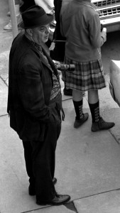
GD Fronabarger shooting parade in front of Southeast MissourianFred Lynch: When photojournalist Fred Lynch is not taking pictures for The Southeast Missourian, a daily newspaper in Cape Girardeau, Mo., he can be found driving around looking at buildings to identify for Ken Steinhoff’s blog. Ken was Fred’s predecessor in the late 1960s at the Missourian.

Fred is always up for a challenge, more so since starting his own blog, F/8 and Be There. Fred shares old photos of Cape Girardeau and their background with readers on the web site. Some of the pictures date back to the 1920s and earlier. Many have been taken by G.D. Fronabarger from the 30s to the 60s. Frony was Ken’s predecessor at the newspaper.

With an eye for detail, Fred checked a photo that Ken took of a child standing outside a store window that had a Santa Claus in it. Ken didn’t remember where it was taken, so he invited blog readers to help.

Looking for clues

Using two different frames of the photo that Ken provided, Fred found these clues:

  • Utility pole
  • Parking meter
  • Two women walking across the street
  • Automobile angle-parked
  • Store across the street with Palace Cafe on the window
  • The two-story building with distinctive second-floor windows, building trim
    above the windows
  • A glass case with a movie poster inside.

Fred first thought the scene was the 600 block of Good Hope. He even took pictures to support the theory. The pole was there and the windows were there, or so he thought. In the end, Fred could not fit the square peg into the round hole.

Wrong street. And wrong town.

The mystery Santa photo was not taken in Cape Girardeau. It was in Jackson.
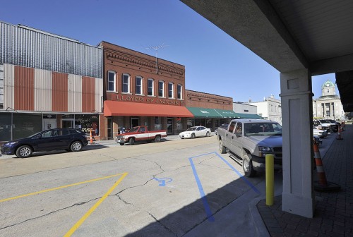
Old Palace Theater and cafe in Jackson, MOFred began his quest with a call to Cathy Hancock at the Jackson office of The Southeast Missourian. She grew up in Jackson. Fred learned from Cathy that Rozier’s department store had a Santa in their window back in the 1960s
when Ken took the photo.

[Editor’s note: I was working for The Jackson Pioneer at the time, so it’s likely that I shot these pictures for it, and not The Missourian.]

Fred learned from Cathy that Jackson had a movie theater at the time, the Palace Theater. Cathy contacted a friend who confirmed there was a Palace Cafe next door to the theater.

Buildings change over decades. The utility poles on High Street are gone, as well as the parking meters. Rozier’s is now High Street Center, an office building. The theater is no more, but one can imagine it was there from the
front. Now it has a church and a beauty salon. The Palace Cafe is now Lloyd’s of Jackson, a bar. And so it goes with progress in Jackson.
.

[Thanks to Fred and Cathy at The Missourian and thanks to all of you who pulled out magnifying glasses to help solve this mystery.]

This is NOT the Home of the Birds

One of the neat things about my Mother is that she’s always up for an adventure. Start the car up and she’s ready to go ambling and ramblin. Some days we just head out and see if we can find a road we haven’t explored.

This time we cruised by Cape Rock, then made a left turn onto Big Bend Road just west of East Cape Rock, where I saw the remnants of what our family had always called the Home of the Birds.

Entrance to Kelso Bird Sanctuary north of Cape GirardeauWhen I was a kid, there were two bird houses on the stone gate posts, but one of them is long gone and the other doesn’t look long for the world. Of course, they’ve been up there half a century (unless someone has replaced them since I was in my pre-teens), so the survivor may outlast me.

Out of the Past didn’t help

I have to admit that I cheat when it comes to doing research. My first stop is The Southeast Missourian for local factoids. This time, though, when I searched for “Home of the Birds,” I got less than a handful of hits and they were mostly in the Out of the Past column compiled by librarian Sharon Sanders. They just kept referring to Southeast Missouri State University construction projects that were eating up the land “north of the campus.”

What made it worse was that I couldn’t exactly figure out WHERE I had taken the picture so I could put it on the map. I thought I had set a GPS waypoint, but I must not have saved it. Even more confusing was that where I thought I was didn’t seem to be anywhere close to the University.

This house picture didn’t help much, either

House across the street from the Kelso Sanctuary Natural AreaI took a picture of this house diagonally across the street from the birdhouse, so I pulled up Google Earth and tried to find IT with no better results.

I learned a long time ago that you don’t have to know everything in the world. You just have to know the people you can call who DO know everything in the world.

I took a stab and sent the pictures in an email to Sharon and to James Baughn, who does a great blog called Pavement Ends, which explores lots of neat areas in Swampeast Missouri. James also has a site, BridgeHunter.com which is a database of historic and notable bridges in the United States. (Full disclosure: I have contributed some bridges to the database and I can get lost in there for hours.)

I’ve never met either person, but I got my first response 21 minutes after the original query. That’s fast. NOT only were they fast, but they were kind enough not to use the phrase, “you fool,” when they pointed out that I wasn’t AT the Home of the Birds.

Springdale Bird Sanctuary

Entrance to Kelso Sanctuary Natural Area north of Cape GirardeauSharon’s first message said, “Hi, Ken. I enjoy reading your Central High reminiscences, even though I’m an alum of Notre Dame (class of 79). The photos you’ve taken, I believe, are of the entrance to the Springdale Bird Sanctuary. Let me do some checking and I’ll get back to you.”

James had slightly different info, but he had the GPS coordinates: “This is the old entrance to the Kelso Bird Sanctuary on Highway 177 north of town. The GPS coordinates are 37.341008, -89.501195 — give or take a few hundred feet.”

When I plugged in the coordinates, BINGO! The place was exactly where I thought it would be. But what’s this business about different names?

It’s now called the Kelso Sanctuary Natural Area

Sharon’s next message cleared it up. “Here is the URL for the Kelso Wildlife Sanctuary. At one time, part of the area went by the name Springdale Bird Sanctuary. Hope this helps.”

There’s not a lot of information on line about the the site, but SEMO does have some promotional pamphlets put out by the Audubon Society of Missouri around 1937 after Judge and Mrs. I.R. Kelso donated 20 acres of land for the sanctuary. The Audubon Society transferred management of the land to SEMO in 1960. I’ll have to visit SEMO someday to read the rest of the story.

The sad thing is I STILL don’t know anything about the Home of the Birds.

Kelso Sanctuary Natural Area


View Kelso Sanctuary Natural Area in a larger map

Santa Search Causes My Head to Hurt

Santa Claus photo printed to emphasize background buildingI’ve been poking around trying to figure out where the Santa picture was taken that I posted here. I’ve looked at Google Maps, Topofusion Maps and every current photo I took last month. My head hurts.

Brother Mark suggested it might have been taken from Shivelbine’s Music on Broadway, but I pretty much dismissed that. (And not just because he’s my brother.)

Here’s a second frame taken from a slightly different angle that shows that the business across the street is, indeed, a bar and / or cafe.  Note the six windows that are visible on the second floor. (Click on the image to make it larger.)

Southeast Missourian photographer Fred Lynch came up with another theory.

Fred’s message and photos

It looks like the Santa in the window photo was taken in the 600 block of Good Hope in the Haarig District.

I shot these photos today.

Photo #1, the building in the background

The south side of the 600 block of Good Hope in Cape Girardeau's Haarig District

In photo #1, notice the three-story building on the left. It appears that is in the background of your Santa photo. At the far right in the Santa photo, notice the two-story building.

Photo #2, the building from which the photo was taken

The north side of the 600 block of Good Hope in Cape Girardeau's Haarig District

The Santa photo has a utility pole in it. In photo #2, notice the utility pole in front of the building.

The buildings have changed much over the years.

I am not sure which building was Unnerstall’s since it has changed.

It could be, it might not be

Like Fred says, the street has changed so much that it’s hard to tell what was there 40 years ago. The best reference I have is a 1979 Cape Girardeau City Directory that lists what business were in the 600 block of Good Hope. Even in 1979 it was depressing to see how many addresses were marked “Vacant.”

North side of 600 Block of Good Hope

Here is what the directory shows for the addresses in Photo #2 in 1979, from right to left:

  • 620 Good Hope (Meyer Supply Company) was Suedekum Hardware
  • 624 Good Hope – vacant
  • 624A Good Hope – vacant
  • 626 Good hope – vacant
  • 630 Good Hope – Unnerstall’s Drug Store. I think that’ll be the light-colored building with the white awning.
  • 632 Good Hope – Mary Dee Cafe
  • 632 Good Hope – vacant
  • 635 Good Hope – on corner of Sprigg (not shown) – Jo Donna Day Dance School (was Shade’s Clothing Store in the 60s)

If Fred is correct, the original picture was probably taken in one of the small shops between Meyer Supply Company and Unnerstall’s.

Does anyone else want to take a stab at it?

Haarig was once a vibrant community

Suedekum’s wasn’t just a hardware store. They set up some great toy train displays at Christmas time. I’ll never forget the year Dad brought home of of their displays. I still have the trains.

There was a bakery right around the corner east of the hardware store that had smells to die for. We would shop for clothes in Schade’s Clothing Store and get prescriptions filled at Unnerstall’s or Cape Cut Rate. One of my barbers was within a block on Sprigg and there was a grocery store nearby.

Farmer’s and Merchants Bank was on the other side of Sprigg and Dad had an office for his construction company upstairs for awhile. I can still remember walking into the bank with a handful small change to deposit in my savings account. (Later I was disappointed to find that my money got mixed in with everyone else’s money and I wouldn’t get the exact coins back.)

[Editor’s note: Fred’s photo blog in The Missourian is one of the most widely-read features in the paper. If you like my photos, you’ll appreciate the ones he comes up with.]