 Wife Lila’s niece, Laurie Everett, wanted to go a photo expedition. The first couple of locations didn’t pan out, so we headed to South Cape (as The Missourian used to refer to it euphemistically) to see if anything was still left from the 60s.
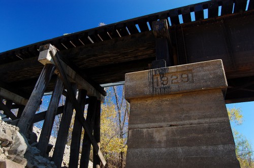
We drove down a gravel road until it became a couple ruts that ended at Cape LaCroix Creek, just upstream from where it dumps into the Mississippi River. On our left was a railroad trestle dated 1929.
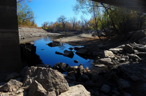
Cape LaCroix Creek looking downstream
 If we were standing on the other bank or on the bridge, we could probably see the river around that last bend. There is another bridge downstream that I didn’t notice until I looked closely at the aerial photo at the bottom of the page.
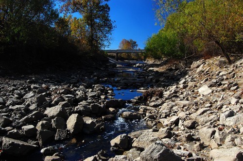
View upstream toward Sprigg St.
 The view upstream looking at Sprigg St. is a much more attractive creek than it was in the days when it carried offal and other unspeakable things from packing plants located on its banks.
Long ago, that bridge on Sprigg would have been a toll bridge leading to Tollgate Hill that I wrote about earlier.
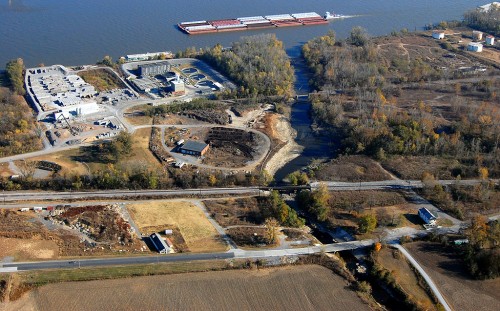
Aerial view of Cape LaCroix Creek and Mississippi River
 Here is a photo of the area taken last weekend. Sprigg St. is at the bottom of the picture. The 1929 railroad bridge is above Sprigg. The third bridge is another railroad bridge. The Blue Hole Garden would have been where the green trailer is at the bottom right of the aerial photo.

What a great day it was!
The area sure looks different now than when it did when our family would drive through on our way to or from our house beside the Marquette School. There were several houses and a few businesses and taverns there then. The floods certainly took their toll on them many times. I remember driving back behind the railroad tracks one time with some friends and seeing all those little houses, some without doors or glass in the windows and people living in them. It is a sight I have never been able to forget.
What is the business (or businesses) in the top left corner of the last picture?
Top left is Kasten Concrete Products. To the right, next to Kasten, is the sewage treatment plant.
I’ve been scanning photos of that area. When I feel like I have a good sample, I’ll post them, along with some of the history of the three “subdivisions” that made up South Cape.
Wow has this changed! This used to be called South Cape?…maybe in the Missourian, but the politically incorrect folk called it Smelterville. I guess at one time their was Smelter there or a guy named smelter lived there…might be good story for you to find out.
Mr. Steel, our neighbor on Oak Hills Drive, was one of the owners of Central Packing, the slaughterhouse you refer to in your fine article. Central packing was a state of the art 1920’s meat packing plant with all the charm that a REAL packing plant can have in one place.
I remember eating Central Brand meats and thinking wow, this made right here in Cape Girardeau, Missouri. I did take a tour of the plant when I was in High School and after the tour really for the only time in my life considered being a vegan…no really I was considering it…until I smelled the Blue Hole BBQ cooking as we were leaving and Mr. Steel asked if we were hungry?
Once again the Blue Hole BBQ inserts itself as a life-changing event.
…and what is the big plant down by the River..
What we typically called “Smelterville” was actually three subdivisions. I read a letter to the editor from around the 30s from someone who wanted The Missourian to be more precise in identifying the exact locations because people in Smelterville were being blamed for things they weren’t doing.
The three subdivisions were Smelterville, Leadville and the Village of Cape Girardeau. Like I said, in the 60s, Missourian style said to call the area “South Cape Girardeau.”
Terry,
See the comment to Sue to identify the plants at the top.
I remember people talking about Mill Town. Was that down there, too?
Margi,
I can’t remember Mill Town, but it must have been in South Cape and it must have been a rollicking place.
Sample from Shanon Sanders’ Out of the Past column:
“June 5, 1907
The saloon in Mill Town, which the County Court in February foisted on the people of Cape Girardeau despite the pleadings of the property owners, is furnishing some great times; the neighborhood is disrupted daily with fights.”
I guess I’ll have to look into that.
1) Smelterville was so-named because a melt smelting operation was to be built in that location but never went into operation due to financial issues.
2) The bridge that you wonderfully document was on the Frisco mainline at milepost 133.5 (measured from Southwest Junction, just west of the Lindenwood Yard in St Louis). Just 4 tenths of a mile north was MP Junction where the Missouri Pacific spur joined the Frisco tracks on its way to the viaducts under Morgan Oak and Good Hope Streets and then out Independence Street (formerly the Cape Girardeau Northern).
3) The railroad bridge in the background (toward the river) is on the old Missouri Pacific spur (formerly the Cape Girardeau and Thebes River Bridge Terminal RR. that came up from Illmo/Scott City.
Thanks for the pictures!
Keith, thank you for the railroad history. I knew I could count on you to chime in.
Mill Town was in the 700 , 800 & 900 block of Giboney and Fountian street with Collage St. on the north end and Smelterville on the south. Just below Fort D. There were rail road track’s to the east & limings mill – upper and lower lumber co. This was between the tracks and the Mississippi river. There was a set of spur tracks going through that sent trains up into town all the way to Kingshighway where the Gouth Brothers block co. was located. Limings Mill, Erlbacher, Urgas, White Cross, McDonald Concrete, and Charles Dietiker Groc. was some of the bussiness that was in Mill Town. Around 10 yrs.ago the Federal gov. and the city bought most of the property up because of the flooding in the area. Not many homes are left in MILL Town. There’s 2 or 3 bussiness thats left.
You actually wrote about a few curious points in this post. I came across it by using Yahoo and I have to admit that I am now subscribed for your blog, it is very good 😉
Ken, I ran across some of your pictures and comments tonight while doing a search on “what is a trot line?” My son and I had been discussing just exactly what WAS a trot line. One thing led to another and I’ve followed you thru several “threads” and find them quite interesting. I grew up at Oran, and we came to Cape for most everything we needed. Just wanted to tell you how much I’ve enjoyed my findings. What about your blog which you mentioned. How do I find that? Also, you was showing some of the old bridges, etc. at Cape and it reminded me: my mother was related to a man named Gebhardt, Ed? maybe, from Cape. In rummaging thru family “stuff” recently, I came to an old S.E. Missourian article which was written at his death. It had information about all the buildings, bridges, etc. he built during his lifetime at Cape. I THINK Houck Stadium was one of them. If you’d be interested in that, I’ll watch for it to surface again. Have really enjoyed your writings I’ve found tonight!
Joyce
Did you see my photos of the Guardian Angel Church and my general photos of Oran?
Sure, give me a date and I can probably find it myself. Glad you enjoyed poking around. No telling what you might find.
I’ve lived here most of my life and never knew that Cape LaCroix Creek went all the way to the river.
Most people mispronounce Trot Line as Trout Line. I’ve set out many a trot line in my day and still doing it.
Ken, thanks for posting about the creek going to the river. Never knew that!
A couple buddies and I made it our mission one day to follow the creek all the way north to its origin. We kept following smaller and smaller ditches until we finally thought we found the tiny gully that was where it started.
I’d never find it again, but it was a fun day.