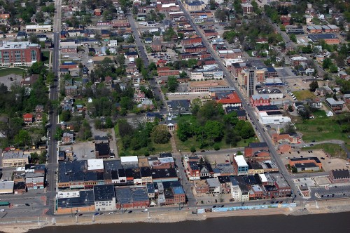
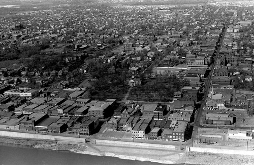
 When I ran the picture of the Town Plaza from the 1962 Girardot, I commented that the shopping center wasn’t much different than downtown’s Main Street, except that it had ample and free parking.
That got me to thinking of this 2011 aerial of the Old Town Cape shopping area. You don’t realize how compact Cape Girardeau is until you see that downtown was essentially bounded by Broadway on the north and Independence on the south. Themis hit a dead end at Spanish at the foot of the Common Pleas Courthouse hill. (Click on the photos to make them larger.)
Not a lot of changes
 There are a few buildings gone and a few new buildings, but the aerials from the middle to late 1960s look remarkably like the 2011 photo.
This post has a collection of links to stories about Main Street businesses.

The relative lack of change in the basic structures downtown and the small size make it easy to model the downtown Cape Girardeau riverfront on a model railroad in two different eras of time.
Great pics Ken. One obvious change from both pictures is the demolition of the Old 1ST National Bank on NW corner of Broadway and Main.
It has been replaced by a beautiful and much needed parking lot because of the redesign of Broadway. My son noted that from the front it looked very much like the USS Arizona Memorial at Pearl Harbor. My old ‘art major’s eye is usually quick to pick that sort of thing up, but I hadn’t noticed the resemblance until he pointed it out. Probably because I never liked the design of that building – even when it was new – and always avoided looking at it. It clashed with and looked out of place next to the wonderful old buildings on Main street and Broadway.
I’ve always thought the same thing of the high rise “Oscar Hirsch Erection”, but there is not much chance that it will be razed for more parking. So we can just appreciate the great views and pictures we can get from the OHE.
Hello. My mother was born (1920) and raised in Cape Girardeau. I’m trying to find photos of her childhood home which has been demolished. The home was located on Rear North Middle Street. Behind St. James AME Church. Thank you