Fender-Bender at Broadway and Fountain

Looking south toward the Idan-Ha Hotel

I’ve got a gazillion wreck pictures in my files, but I’m  going to run only those that are of unusual vehicles, unusual circumstances or have interesting backgrounds. This fender-bender between a car and a taxicab at the corner of Broadway and Fountain in 1966 fits the criteria. I assume the two guys in the foreground were the drivers from their universal “Oh, Bleep” pose.

The old Idan-Ha Hotel is on the corner. I spent many a lunch hour in the coffee shop there when I was working at The Missourian.

Looking north toward the Marquette Hotel

The Marquette Hotel is on the right and the H&H Building is on the left.

Officer Fred Kaempfer directs traffic

I looked at the officer directing traffic and thought I had a shot of him from another occasion. Yep. It was a portrait of a guy with sort of a soulful look in his eyes. I remembered him as being one of the nicest guys who ever wore a uniform.

Wife Lila immediately recognized him from her days working at the Rialto Theater. The only problem was that we couldn’t think of his name to save ourselves.

Fortunately, we have house guests from Cape Girardeau staying with us. Lila’s sister, Marty Perry Riley (Class of 68) and her husband, Don Riley (class of 67) are in town for Marty to do a chalk drawing in the Lake Worth Street Painting festival this weekend. Son Adam’s company, DedicatedIT has brought her down the last three years to do the drawings. (It’s chilly down here this year, but it’s generally not hard to convince her to come to Florida in February with the kind of weather Cape’s been having.)

As soon as I showed them the photo, they both said, “Fred Kaempfer.” Don had been a Cape police officer himself.

What I didn’t know about Officer Kaempfer was that he was a song writer who came up with “Keep Walking On,” sung by Ken Roberts, in 1970. Fred died in 2004, at 80. His obituary fleshed out his life. He worked at Leming Sawmill for 25 years, was a Cape policeman from 1965 to 1973, and was a Scott City policeman from 1973 until he retired in 1978.

A letter to the editor in The Missourian after his death pointed out something else. Few know that during World War II Kaempfer fought in five major campaigns: Sicily, Central Europe, Normandy, Rhineland and the invasion of France, where he was awarded the Medal of Freedom.

View to the east shows First Federal Savings and The Southeast Missourian

It was a hot day in 1966, if the temperature sign on the First Federal Savings is correct – 88 degrees. This is quite a contrast with a Frony picture taken at the same intersection during a snow storm when the temperature was 28 degrees on the sign. You can see it in Fred Lynch’s Southeast Missourian blog.

Notice the phone number on the side of the cab: ED. 5-4433. ED stood for Edgewater. Jackson was the Circle exchange.

You can see The Missourian Building and the Royal N’Orleans, but the KFVS tower hasn’t been built yet.

The Idan-Ha is gone

The Idan-Ha Hotel caught fire a couple of times and was torn down. Here’s what it looked like on Oct. 24, 2009.

The Marquette Hotel escaped the wrecking ball

The future of the Marquette Hotel was very much in doubt for many years, but it looks like it’s taken on a new life. The canopies over the doors were more interesting when the building was a hotel, but, overall, the building looks better than it has in decades.

Note the KFVS TV building sticking high up into the sky.

Capaha Park, SE Hospital, Franklin School

Missourian photographer Fred Lynch had a Frony picture of the Capaha Park Lagoon being drained and being cleaned in 1962 in his f/8 and Be There blog. That reminded me that I had just seen some aerial photos I had taken of that area April 14, 1964, after the work had been completed.
I don’t know if Ernie Chiles and I had a mission this day or if we were just flying around for the fun of it. I’ll be publishing other photos from the flight from time to time.

This overall shot shows Capaha Park in the lower left-hand corner; Houck Stadium is up and to the left; the Cape Traffic bridge and the river are at the top; Franklin School is the large building with empty space behind it just to the right of center and Southeast Hospital is diagonally across the street from the park. The white smear at the top right is a reflection off the plane’s window. (Click on the photos to make them larger.)

Same photo, with Capaha Park area enlarged

Disturbing the peace

You can see two cars parked on Cherry Hill across from the Rose Garden. I remember the day with The Missourian’s cop reporter came back from checking the overnight police blotter.

“I’m never going to be able to get this in the paper, but it’s too good not to share. One of the items, in typical cop-speak, read, ‘While on routine patrol of Capaha Park, I noticed a crowd of people gathered around a car parked on Cherry Hill. The crowd dispersed when I approached. I shined my flashlight through the driver-side window and witnessed a couple in sexual congress. I tapped on the window. When they finished the act in which they were muchly engaged, I cited them for disturbing the peace.’ To my way of thinking,” the reporter continued, “the couple should have filed against the cop for disturbing the piece.”

If you look closely at the parking lot to the right of the swimming pool (the white area left of center), you can see something tall sticking up. I wonder if it’s part of the carnival rides Terry Hopkins mentioned in the post about the trains in Cape parks.

… I did notice that in the background on the middle shot you could see the the old carival rides that used to be in the park. Mike Stovall and I used to work for “Booty” King the guy who owned them. I think I made the princely sum of .35 an hour, plus we got a deal on a hot dog and coke each day! Big fun and living LARGE when you were fourteen! Thanks for bringing back this memory!

A view looking east from Caruthers

The front lawn of Central High School is at bottom right; Franklin School is in the right center; Southeast Hospital is at left center; the road running from left to right at the bottom of the photo is Caruthers. The curvy road at the left is Broadway. I always thought of Broadway as being fairly straight, but it has some significant curves.

Franklin School neighborhood

Franklin School is in the middle. Independence runs diagonally at the right; Themis is just to the right of Franklin School and Broadway runs in front of Capaha Park.

I’m curious about the large white house at the bottom of the photo. It has a street or driveway that looks like a question mark leading to and around it. It looks like something I should remember, but I’m drawing a blank. Anyone?

Southeast Hospital at night in 2009

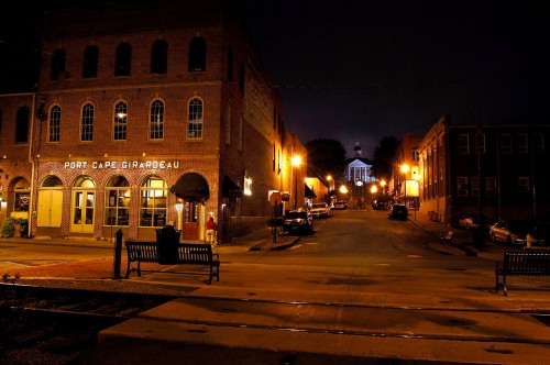
When I was in Cape last fall, I played around with some night time exposures of buildings along Broadway (and Wimpy’s). The tiny Southeast Hospital of 1964 has grown to gobble up the surrounding neighborhood.

Pfister’s Drive-in

Missourian photographer Fred Lynch and I have been searching like crazy for photos of Pfisters. He came up with some in his Jan. 11, 2009, f/8 and Be There blog.

This is the first one I’ve been able to find. This single shot was on the end of a roll of undated pictures I had taken of the SEMO football team working out on a trampoline. It’s definitely Pfisters because of its round shape, the ordering speakers and the  “HERO” sign in the far upper left.

Hero sandwiches were the signature specialties at Pfisters. The guy behind the wheel ordering looks a little like Tom Holt, but I won’t swear to it. Anybody else want to make a guess?

I can’t quite read the menu

I tried to enlarge and enhance the menu in the photo, but I can’t do the magic that you see on Bones where they take a fuzzy picture with half the pieces missing and have it suddenly appear razor sharp.

I can make out that Reuben Sandwiches were available. You could wash them down with a Hawaiian Cooler for 20 cents or an Ice Cream Soda for a quarter. A chocolate milk was 10 or 25 cents, depending on size.

Click on the picture to make it larger. Maybe your eyes are better than mine.

I hope to stumble across more pictures of the drive-in.

Weekend nights saw an endless stream of traffic cruising between Pfisters and Wimpy’s. I documented the Wimpy’s piece a couple of days ago.

A Chinese restaurant replaced Pfisters

Wimpy’s in 1966, 1967 and 2009

Wimpy’s Intersection in 1966

My friend, Fred Lynch, Southeast Missourian photographer, had a picture of the original Wimpy’s building taken in the 1940s in his blog.

I spent some time at the second iteration of Wimpy’s, when it moved across the street to the corner of Cape Rock Drive and Kingshighway. I went into the store a lot of times as a kid, but it wasn’t a normal teenage hangout of mine. I think I was more of a Pfister’s kind of guy.

I took the time exposure above sometime during the summer of 1966. I don’t know if I shot it for a story or if it was just a finger exercise to practice shooting night photos. The headlights and taillights of cars left the light streaks.

Busy intersection for wrecks

I have pictures where Wimpy’s was the backdrop for one of the many crashes that occurred at the busy intersection before traffic signals were installed. My Dad’s construction company had the project to widen that section of Kingshighway. The state created room for the turn lanes by turning the shoulder into travel lanes, something he thought was a mistake. He thought they should have widened the road, but you build to the specs, not to what you think is right.

This picture from 1967 appears to be some kind of minor motorcycle accident.

Wimpy’s was gone in 2009

I took this time exposure Oct. 13, 2009. Wimpy’s has been replaced by a bank, which is closed and for sale. Traffic lights make the intersection safer, but there are a lot fewer cars to control at night after the demise of Wimpy’s.