Mrs. George Ketcham, Backpacker

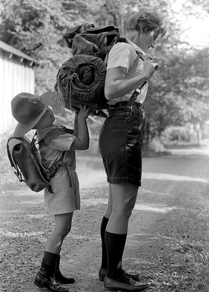
The August 8, 1967, Missourian caption said “Even Charles, son of Mr. and Mrs. George A. Ketcham, wants to assist his mother with her back pack, a 20-pound weight that she has been wearing for months in preparation for a hiking vacation next week when she will travel about 10 miles a day, walking over the Appalachian Trail with her husband, and her father.” Click on any photo to make it larger. You can read the full Emily Hughes’ story here.

Hike will start at Nantahala, N.C.
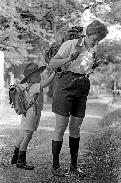
I guess someone thought the shot that ran in the paper was cuter than this one that shows Charles’ face. Mrs. Ketcham’s mother was going to keep the six-year-old while the hikers start out north of the Georgia border at Nantahala, N.C.

“Mother will drive us to where we get on the trail, 30 miles away,” Mrs. Ketcham said, “and then we’ll take three days to get back, rest and repack. Then she’ll drive us to the other end and we’ll hike the 20 miles back in two days. After that, well see how we feel. If we’ve had enough, we’ll turn around and head home.”

She had been working up to carrying a 20-pound pack since May. She wore it when she was working as a counselor during the Junior Cadet Day Camp so she wouldn’t lose conditioning.

Grandma Gatewood
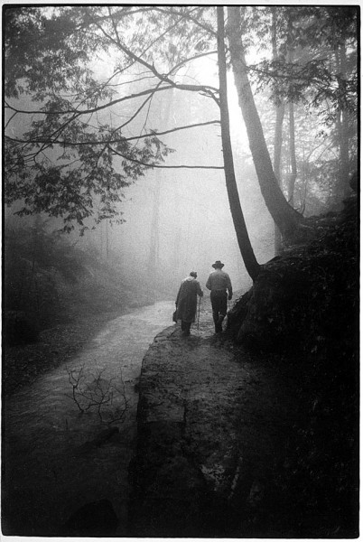
I’ve been scanning photos of  another hiker, Grandma Gatewood, for a future story. This is a shot you’ve seen before.

This remarkable woman was one of the first extreme hikers and an ultra-light hiking pioneer who was the first woman to hike the whole 2,168-mile Appalachian Trail in one season. She did it in 1955 at age 67, wearing Keds sneakers and carrying an army blanket, a raincoat, a cup, a first aid kit, one change of clothes and a plastic shower curtain, all stuffed in a homemade bag slung over her shoulder.

She hiked it again in 1960 and then again at age 75 in 1963, making her the first person to hike the trail three times (though the final hike was completed in sections). She also walked 2,000 miles from Independence, Mo., to Portland, Ore., averaging 22 miles a day.

This was shot in 1969 when she was walking in Hocking Hills State Park

Vocational-Technical School

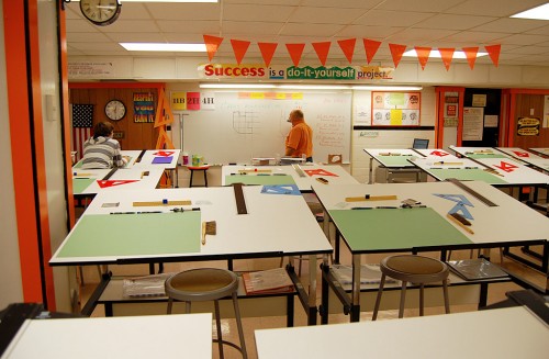
This photo of the new Vocational Technical School on North Clark behind Central High School ran in The Missourian’s 1968 Achievement Edition. The story said 306 students were attending classes there: 300 who were taking some training at Central High School and six who were going to Campus School. There were 206 adults, including both men and women, taking classes in the evening. (Click on the photos to make them larger.)

Drafting room considered best in state

The drafting room was considered to be the best of any school in Missouri. I wonder how it would compare with this one in Central Junior High School (our old Central).

Here are photos of automobile training being handled at Central High school.

Teacher pay below national and state averages

Voters were going to be asked to approve a 35-cent tax levy in the April elections. Supt. Charles E. House said that Missouri teacher salaries were below the national average, and that Cape salaries were below the state average. A graduate of State College with a degree in education and no experience could expect a salary of $5,100 in Cape. The median outside the area would be $5,467; the average would be even higher.

Of course, putting it in perspective, in 1968 I thought that if I ever made $10,000 a year I’d be having caviar and lobster every night.


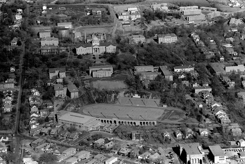
SEMO in 1966 and 2010

This 1966 aerial of the Southeast Missouri State College campus was misfiled, so I just ran across it.

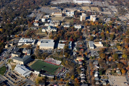
One big change when you compare the 1966 photo with the November 6, 2010, version is the missing dozen-plus homes and Werner’s Super Market that used to be in the lower left corner around Houck Field House.

When this photo was taken, Kent Library hadn’t been expanded and land clearing was just starting on the housing towers at the top center. The open area at the top left has been turned into buildings and parking lots.

Southeast Missouri State University 2010

It’s good to see the terraced hillside on the east side of Academic Hall hasn’t been turned into a parking lot yet.

Here are some past stories about SEMO’s campus:

Downtown Cape Panorama

This panorama photo is made up of six aerial photos taken April 17, 2010. It ranges from William Street on the left to north of Broadway on the right. The western boundary is just beyond Fountain St. The gray parking lot at the top left is Cape’s City Hall on Independence

Most panoramas are taken from one spot and the camera swiveled on a tripod. In this case, the “tripod” was Ernie Chiles’ plane flying along at about 100 mph. Because the angle was constantly changing, there is some freaky distortions of the buildings on the edges of the photo, particularly St. Vincent’s Cathedral on the left. Still, it’s a neat effect. I made it larger than usual, so you may have to scroll around to see it all.

 Broadway Theater was a panorama

When I shot the interior of the Broadway theater, I stitched together six photos to show the whole room. It’s a way to cover a wide area if you don’t have a super wideangle lens.

The super-secret assignment

I haven’t fooled around much with panoramas because they were a real pain back in the days of film and paper prints. One day The Big Boss called me in and said he needed some aerial photography done for a super secret project for someone he wouldn’t name. I wasn’t supposed to discuss the assignment. Some days you ask questions. Some days you salute and say, “Yes Sir.” This was the latter.

In 2012, you’d call up Google Earth and have what you wanted in minutes, but this was in the days when the Google Earth guys were still wearing diapers, so that wasn’t an option.

The chopper ride was the fun part

So, I chartered a helicopter, took the door off, put on a safety harness, stood on the skid and leaned out into space so I could shoot straight down as much as possible. It was cool. Because the boss wanted a couple block area covered and in close detail, we flew multiple grids and I banged off a couple hundred frames. That was the easy and fun part.

When I got into the darkroom, though, I realized that I wasn’t as smart as Photoshop is today. No matter how straight to the ground I had tried to hold the camera, there was always a slight angle that kept the prints from lining up.

The next day, I spread out enough prints on The Big Boss’s floor to just above cover the whole shebang. I explained the technical problem, then I handed him two sheets of aerial photos of the area from the county’s tax assessor. He said I wouldn’t need to muck with making the prints; the county photos would do fine. (He was pleased enough with my ingenious solution that he didn’t think to ask why I hadn’t done that in the first place.)

So, what was the whole super secret deal about? I have no idea to this day. From time to time I’d drive through the neighborhood to see if any changes were taking place, but nothing ever sprouted up. I don’t know if the project was scuttled or what happened. At least I got a neat chopper ride out of it.

Other downtown shots

Downtown Cape Girardeau from the air and ground (includes other links)

Common Pleas Courthouse from the air

St. Vincent’s Cathedral and downtown