 Missourian reporter Melissa Miller wrote about the Isle of Capri Casino’s drive to purchase property for the new $125 million casino approved this week. I’m not going to even try to cover all the aspects of the run-up to the casino decision. That’s what your daily newspaper is for.
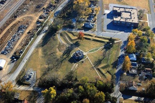
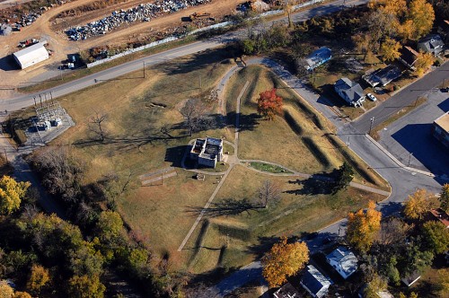
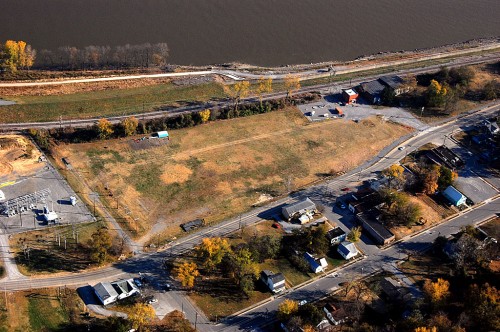
The development will center around the open space that used to be the the old shoe factory shown in the photo above I shot Nov. 6, 2010. The white building at the bottom left of the frame is the Cape Mart convenience store at Mason and Main Streets. The small red brick building at the top right is the Mill Street pumping station. The road running left and right at the bottom is N. Spanish Street; east of it is Main Street. (By the way, you can click on any photo to make it larger. Then, you can click on the left or right side of the image to move through all of them.)
Melissa’s story says the casino will be bounded on the south by Mill Street, on the north by Mason Street and on the west by Main Street.
International Shoe Factory in early 70s
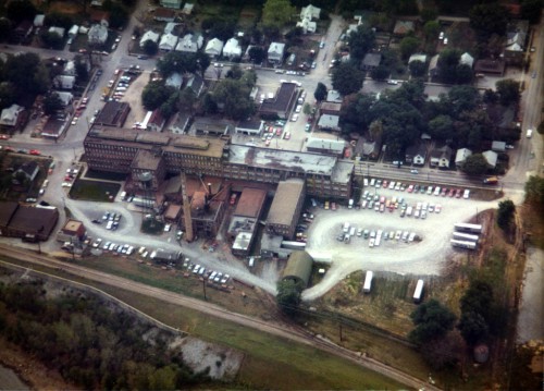 When I shot this aerial in the early 70s, the shoe factory was still in production.
The facility dated back to 1906 when the Roberts, Johnson and Rand Shoe Co. of St. Louis decided to build its first branch facility in Cape after the Commercial Club agreed to provide the five-story building for free as an incentive to relocate.
The smokestack in the photo was built in 1926. A Feb. 5 Missourian story said, “The tallest smokestack in Cape Girardeau was completed at the International Shoe Co. plant this week. Requiring four months for construction, it towers 175 feet in the air, being 50 feet higher than the one formerly in use at the large plant here. The stack, of the most substantial build, is constructed of tile, cement and steel and was erected at a cost of $15,000. It is even larger than it appears, being 24 feet in diameter at the base and tapering to 10 feet at the top.”
Wanted: girls over 16
The International Shoe Co. had a standing ad running in the Missourian for most of 1918:
Wanted, Girls over 16 years of age to work on power sewing machines; pleasant surroundings and good pay while earning. International Shoe Co. Cape Girardeau.
By 1921, the building was expanded. Depending on which news account you read over the years, the total square footage of the factory was either 165,000 or 138,000 feet.
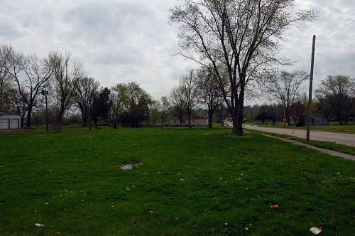
Nothing left of it today
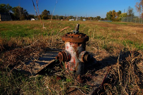 This photo, taken from the southeast corner of the property looking north in 2009, shows that virtually nothing is left of a business that employed nearly 1,500 workers in its heyday.
$10 million in shoes shipped in 1925
From the Dec. 31, 1925 Missourian: Nearly $10,000,000 worth of shoes has have been shipped from the International Shoe Co. plant of Cape Girardeau during the twelve months just passed… The total of shoes manufactured at the plant during the year just closed, reaches 3,164,080 pairs – enough to furnish every man, woman and child in Cape Girardeau with 175 pairs. Now in its 18th year of operation, the shoe manufacturing plant here is constantly expanding and increasing its efficiency.
An army of employees, most of whom reside in or near Cape Girardeau, are employed throughout the year. This body of workers has been enlarged by 200 since last year, 1,600 men and women now being employed as compared to 1,400 at the close of 1924… The average weekly payroll for a six-day week is $35,000…Another year has passed without serious injury… No death or accident of serious consequence having been recorded during the 18 years that the factory has been in operation.
Shoe factory worker scalped
I’m not sure if the shoe company would qualify this as an injury of “serious consequence, but I’m sure Mrs. McCrite would:
June 24, 1926 – The condition of Mrs. Octavia McCrite, who is in the Cape Girardeau hospital following the loss of her scalp in an accident at the factory of the International Shoe Co. Saturday, was today reported to be unchanged.
Mill St. edge of property
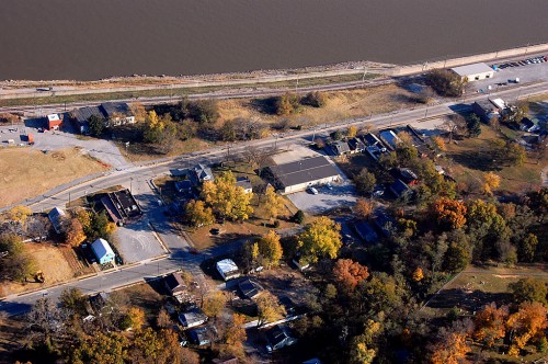 This photo shows the intersection of Mill Street and Main Street. There is talk about relocating Main, so I suppose they’re going to shift it a bit to the west to make the casino property wider and to eliminate the slight curve in Main.
9,500 miles of shoes shipped
Missourian reporters struggled to find new ways to tell how productive the shoe company was every year in a business roundup.
Dec. 31, 1927 – Three million pairs of shoes, made in Cape Girardeau, if placed end on end, would reach 9,500 miles, more than twice the distance from New York to San Francisco, or would require a train nearly three miles long to haul them, based on the average length of men’s shoes made at the plant. The wholesale value of the shoes made at the local plant is about $14,000,000. The factory is operated on a 50-hour-a-week basis, the employees working nine hours a day the first five days of the week and five hours on Saturday.
Mason and Main Street
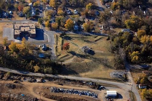
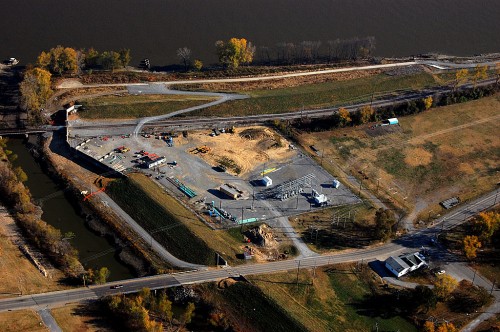 This is the north end of the property. The white building at the bottom right of the frame is the Cape Mart convenience store at Mason and Main Streets.
Shoe factory largest in the world
Oct. 18, 1932 – The International Shoe Co. factory has kept from 1,150 to 1,400 employees steadily at work never less than four days a week manufacturing slightly more than two and a half million pairs of men’s fine dress shoes. One million dollars of the annual payroll of Cape Girardeau is maintained by this one concern. This is the largest dress shoe manufacturing plant in the world.
In 1929, The Missourian asked residents to list the city’s greatest accomplishments in the past 25 years. The bulk of the respondents listed the shoe factory, the Marquette Cement Plant, the Missouri Pacific railroad and the new Mississippi River Traffic Bridge.
Red Star and Honker Boat Dock
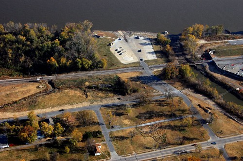 The empty lots in the Red Star district also reflect the beginning of the end. Too many floods in too short a time dealt a death knell to the vibrant community north of the shoe factory. By 1998, the city had acquired 94 of 114 flooded homes that were eligible for a FEMA buyout program and had started tearing them down.
By the 1960s, more and more of the stories talked about union troubles, plant slowdowns and plant closings in the shoe industry in general. Cape wasn’t immune to it. In 1994, a syndicated story said that once Missouri was second only to Maine in shoe production. Now, the United States, the story continued, had lost 70% of its shoe markets in imports. Up to 87% of all shoes sold in this country came from overseas, with about 60% of those being made in China.
In 1984, The Florsheim Shoe Company built a new plant at Highway 74 and West End Blvd. The old factory was donated to the Chamber of Commerce, which debated for years what to do with it.
In 1994, Florsheim Shoe Company was named Industry of the Year in Cape for its 450 employees who turned out 3,100 pair of shoes a day for an annual payroll of $6 million. By 1999, the work force had dwindled to 300 workers. Not long after that, the manufacturing process was moved to India.
Cape Mart convenience store
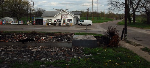 The Cape Mart convenience store at the corner of Main and Mason is one of the properties optioned to the casino owners, so I would suspect that its days are numbered, too.
In 1964, shortly after the factory was donated to the Chamber of Commerce, The Missourian wrote an editorial addressing the potential for developing the area. “The first fundamental question to be faced is whether to save the building or clear the site for other uses.”
“There is some reason to believe that the site would be far more valuable without the five-story factory building than with it. Six acres of cleared property protected by a floodwall and served by a railroad in downtown Cape Girardeau is a considerable asset. Ideas that come to mind include special commercial purposes, an industrial site or the location for high-rise apartments or a hotel.
“The factory and its site are nothing less than the key to the future improvement and development of the entire North Main Street neighborhood about which there has been considerable talk of renewal.”
Red Star neighborhood 4th and Main
 When I typed the search phrase “shoe co” into the Google News Archives, I was struck at how much a part of Cape Girardeau the shoe factory under all its names was.
Scores, if not hundreds, of names popped up: in the early years, it was couples who worked at the factory getting married and starting families. In later years, right up to the present, it was in the obituaries of folks who had worked there for 20, 30 and even 48 years.
A faux riverboat gambling casino may bring all of the good things to Cape that the owners promise, but I doubt that it will ever become a part of the fabric of the community that the shoe factory was.

