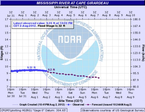
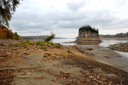
 The Mississippi River keeps creeping lower and lower. On July 19, the Cape river gauge read 11.23. On August 2, it was down to 9.35. That’s not good enough. It needs to be at 7.0 feet in Cape to be able to walk across to Tower Rock, locals tell me. Here’s where you can check the river stage at Cape. By the way, you can click any photo to maker it larger.
Itchin’ to go
 Members of the Southeast Missouri Geocaching fan page are just itching to get on top of Tower Rock so they can claim bragging rights to an exotic cache. If you’ve never heard of the hobby, here’s a website that does a good job of explaining it.
I was going to meet Cacher Randy Friday to see if we thought it was safe to make it to The Rock for the rest of the group on Saturday. Unfortunately, I have to swing by LeGrand Bros. Transmissions first. My check engine light came on and I wanted to make sure it wasn’t something serious before being That Guy stuck on the side of the road with his hood up and a mournful expression on his puss. You might recall the sad story of my transmission from last year.
Anyway, a nice guy hooked up a $9,300 computer to my car, went for a short test drive and said I needed a new throckmorton that bolts onto the franjipannni. The good news is that it’s on the exterior of the trannie and shouldn’t take more than two heartbeats and a hamburger to fix. (Once the part gets here, that is.) The best news is that it’s covered under warranty.
So, if Sir Randy gives me the All Clear, I’ll sound the trumpets and a whole herd of folks will be hanging all over The Demon The Devours Travelers on Saturday. If not, they’ll try next weekend. I just won’t be there to see it.
Surely they need a souvenir
 Maybe they’ll stop by the Altenburg Lutheran Heritage Center and Museum where they can pick up a souvenir copy of my book on Tower Rock.
FRIDAY MORNING UPDATE
Cacher Randy called around 10 a.m. to say that it’s a no-go. He waded out until the water was waist-deep (deeper than I would have gone) and felt the current “tugging” at him. He decided to turn back. Wise decision. He also noted that the bottom was slippery.
How do I get there?
A reader asked how to get there. This map shows you the scenic way I get to Altenburg on my bike. In my Tower Rock book, I describe the path from Altenburg to Tower Rock this way:
Tower Rock isn’t some place you stop on the way to somewhere else. You have to REALLY want to go there.
You start by passing through Altenburg on Missouri Highwy A.
After going up and down some steep hills, just before you get to what’s left of the German pioneer village Wittenberg (population: two buildings and three people), you’ll see a small sign off to the right pointing to Perry County 460, a steep and washboarded gravel road.
Off to your left, you’ll pass the Texas-Illinois Natural Gas Pipeline bridge, called the longest suspension pipeline in the world. It carries gas from Texas to Chicago.
Not far from there, the road narrows. Now things get interesting if this is your first trip. You’ll make a sharp 90-degree bend to the left and cross over the BNSF railroad tracks and make an immediate right-hand 90-degree turn paralleling the river. There are no warning devices, so Stop, Look and Listen before getting on the tracks.
The stretch along the river is narrow and there’s a steep drop-off to the water, but you seldom meet a car. Eventually, you’ll come upon a parking area at the Tower Rock Natural Area, donated by Mr. and Mrs. Charles Bussen to the Missouri Conservation Department.
