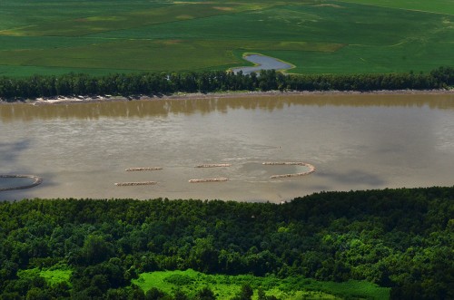
 Ernie Chiles and I were puttering around in the air someplace between lost and found when we spotted these strange structures in the Mississippi River.
You’d think Ernie, my former Central High School earth science teacher would be all up on this kind of thing, but he dodged my question by either (a) pretending he couldn’t hear me over the engine noise, or, (b) saying “look it up and get back to me by the start of class on Monday.”
Click on it to make it larger.
So, I looked it up
You are looking at blunt nose chevrons. Here’s what the Upper Mississippi River System Environmental Design Handbook has to say about them:
Blunt Nosed Chevrons provide nose protection for islands while providing slower moving waters for fish habitat. Large rock used to provide structural stability and openings for habitat benefits. A navigation structure called a chevron dike was developed to improve river habitat and to create beneficial uses of dredged material. These structures are placed in the shallow side of the river channel pointing upstream. Their effect is to improve the river channel. When dredging is needed to improve the main navigation channel, dredged sediment is deposited behind the chevron dike. These small islands encourage the development of all four primary river ecosystem habitats. In addition, various microorganisms cling to the underwater rock structures, providing a food source for fish.
Fifty-one fish species and a highly diverse group of macro invertebrates have been collected in and around the structures. The 8 years of data also show a high presence of young … and juvenile fishes inside of the structures, which suggests that the structures are being used as nursery habitat. The data also shows that the outside edges of the chevrons are providing excellent habitat for quality-sized catfish. Catch rates inside the chevron have been more than double the catch rates outside of the structures.
[I couldn’t tell where the experimental blunt nose chevrons had been constructed.]
Where were we?
Based on photos taken on either side of the structures, I’d have to guess we were south of Commerce. I tried to find the structures on Google Earth, but the river was a little higher than when Ernie and I were up, so they may have been mostly covered with water. The foliage in the foreground might be on Goose Island, west of Horseshoe Lake.
I hope my extra credit homework will result in Ernie raising my grade in Earth Science circa 1963.
Oh, and in case anyone asks, these are called “river training structures.” The rock things we usually see going from the bank and pointing downstream are called “wing dams.” Newer ones are “notched,” which still help maintain the river channel through “scouring,” but do a better job of creating diverse habitats than a solid dike.
