SEMO Plans to Erase Landmark

River Campus 10-20-2008 First handball court west of the Mississippi River
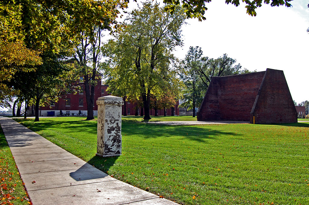
There were a number of things that let me know I was getting close to home: going down that last hill at Thebes Gap, catching the first glimpse of the Mississippi River as it curved around Gray’s Point, spotting the Common Pleas Courthouse and the dome of Academic Hall poking above the trees… Once we made the white-knuckle passage across the Traffic Bridge, I’d look off to the left, not to see St. Vincent’s College, but to spy the strange brick structure on its lawn. I didn’t know exactly what it was, but it was a sign that I was home.

When I researched a piece on the 5th anniversary of the River Campus, I discovered a report filed with the National Register of Historic Places saying the court was constructed in 1843 and was supposed to have been the first handball court west of the Mississippi River.

James Baughn reads the fine print

Aerial photos of Southeast Missouri State University River Campus areaThe December 16 Missourian ran a routine story about the SEMO regents approving 96,000 square feet of new construction at the River Campus. There was an aerial photo overlay, but I’m sure most readers didn’t look at it closely. I’m guilty as charged.

Missourian webmaster James Baughn, who does one of three must-read blogs in the paper, is one of those detail kind of guys who notices things. He discovered that the new construction will erase one of the oldest structures in Cape Girardeau, one built by Joseph Lansman. Who is he? Thanks to Baughn’s research, we find that he was the guy who was probably responsible for SEMO being in Cape in the first place.

Baughn notes “[Louis] Houck was able to work his magic to steer the newly formed Board of Regents toward Cape, but Lansman helped seal the deal. He agreed to donate land he owned at the site of Fort B, the old Civil War fortification on a hilltop north of town, well away from the mosquito-laden swamps. During a crucial meeting at the St. Charles Hotel (built by Lansman), the regents made the final selection of Lansman’s site for the new college.”

SEMO, which touts one of the few undergraduate historic preservation programs in the country, assures us that they will incorporate a “select” number of bricks from the handball court into the facade of the new River Campus building. If they were in Philadelphia, they’d probably scrap The Liberty Bell and incorporate the clapper as a door knocker. I mean, why hang on to that old thing? Nobody’s going to ring it with that crack in it.

Holy Crapola! I’ve been ripped off

Southeast Missouri State University River Campus area
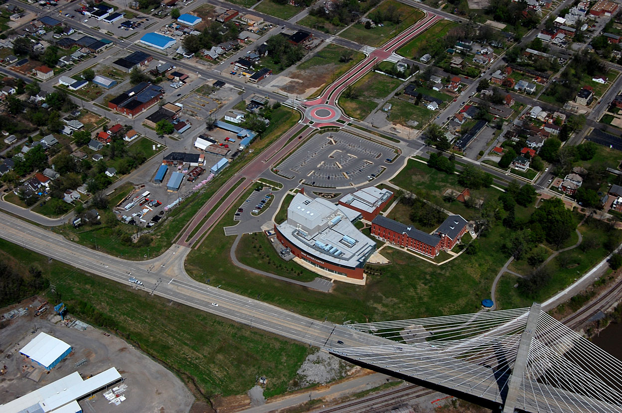
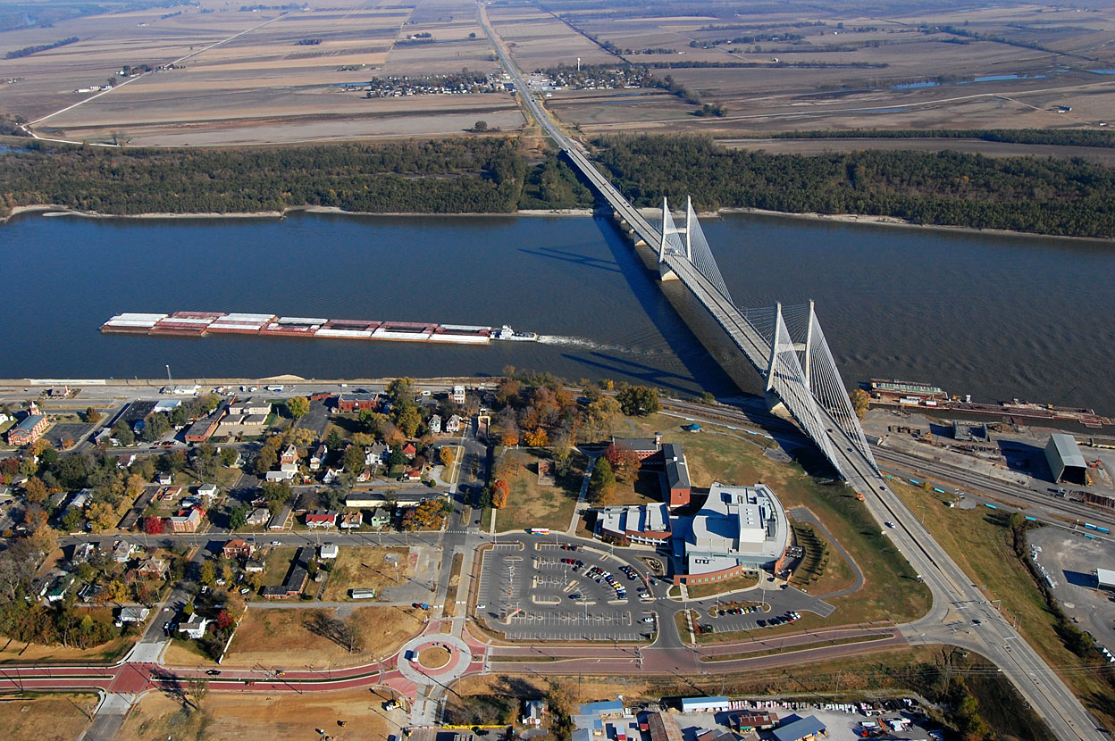
I followed a link on Baugn’s blog to a SEMO publication that details the constuction project. Guess what they have on the first two pages? This copyrighted aerial photo showing the River Campus I shot November 6, 2010. I can’t wait to make some phone calls tomorrow morning to SEMO and the Lawrence Group to talk about appropriating photographs for commercial use without compensation. (As always, you can click on the photos to make them larger.)

Frame Two of my purloined photo shows clearly that they are targeting the lawn and handball court area that gives the site its quiet beauty, second only to the trees area and terraces overlooking the river. (They’ll go next and SEMO will sell “preservation toothpicks” made of the trees.) It would appear to me that there is plenty of space occupied by parking lots that would be perfect for the expansion. Put two floors of parking under the new buildings and you could leave the lawns and terraces alone.

Thanks, Mr. Baughn, for the heads-up.

On the Wrong Side of the Tracks

I made a swing up to Cape Rock to check out the river level and the huge sandbar hugging the Illinois banks. After taking a couple of shots, I pulled into the small park at the bottom of The Rock to get a different angle. You can click on the photos to make them larger.

Tracks were open

The BNSF tracks were clear to the south. As soon as I crossed the main line and siding and looked north, I spotted the sunken barges I posted on October 21.

Where’d that train come from?

I spent about 45 minutes shooting the barges, then turned to see a long freight blocking my path back to the parking lot. This young fisherman was stuck on the wrong side of the tracks, too. Since these cars were parked on the siding, I thought maybe they were making way for a faster freight on the main line. Since most local trains aren’t that long, I decided to start walking south to see if I could get around it.

This one one of those situations where Plans A, B and C all involved swimming: I had the Mississippi River to my east; if the train extended south to Red Star, I was going to run into Sloan Creek; if it went too far north, there was Juden Creek to contend with.

Does this thing have an end?

About a quarter mile down the tracks, I ran into two fishermen walking north. “How far does this thing stretch to the south?” I asked.

“A long way,” one replied.

“Well, the head end of it is out of sight at Cape Rock, so I’m going to keep walking south.”

Way off in the distance, I could hear a train horn. Probably blowing at the crossings in town, I thought. Shouldn’t be too long before it passes, then the train on the siding will pull out, I was hoping. The clouds were building up, the wind was getting stronger and all I was wearing was a light long-sleeve shirt covered with a wool vest I had picked up for twelve bucks off a remaindered rack at Monteagle Pass.

Walking on railroad ballast is no fun, but I didn’t have much choice: there had been a rain recently that made the non-gravel areas full of soft mud. Adding to my distress was the audio book I had been listening to on the trip: Stephen King’s The Long Walk. I kept fearing that if my pace dropped below four miles an hour that someone would terminate me.

A little beyond this point, I ran across a bunch of bones on and around the track. They were too big to be a dog and they weren’t human, so I assumed that a deer picked a bad time to cross the tracks. I picked up a clean piece of vertebrae as a souvenir for Brother Mark.

Here comes the local

It was taking a long, long time for the northbound train to get here for all the whistling it was doing. When it pulled into sight, it had two power units, which meant that it was probably the local freight I shot back in April 2010.

Caboose confirmed it

When the caboose passed, I knew it was the local, probably headed to Proctor & Gamble to drop cars. I decided I’d start walking north again, figuring that once the local passed the stopped freight, it would pull out of the siding.

Getting ready for crew change

Then, the local started backing up and conductor Randy Graviett popped out of the caboose. He explained that they needed to do a crew change. They were going to back the train up far enough he could hop on the engine and go up north of Cape Rock to pick up a new crew. He said the train on the siding was being held up until a dispatcher in Texas told it to proceed.

Delay let me shoot Dredge Potter

By the time I made it north to the parking lot across from Cape Rock, the freight on the siding had pulled out. That was the good news. The bad news was that the local was blocking my path north and south as far as I could see. While I was waiting for the train to move, I spotted the Dredge Potter and her pushboat, The Prairie Du Rocher headed upriver. Not a bad day when you can shoot three stories in a three hours.

I was beginning to get chilly, so I decided to see how far north the local stretched. I finally came upon the head end about half-way to Twin Trees Park. Once I got back on the road, I started counting train cars. I can’t remember now if it was 29 or 39 cars back to the parking lot. I’m going to guess my total walking for the afternoon was about four or five miles on railroad ballast.


Perfect River Night

I made a run downtown, but the place I needed to go was closed, so I took a stroll down to the riverfront. It was a perfect night. There was a guy sitting near the Broadway entrance to the floodwall playing a guitar. Next to him was a buddy with a huge boxer on a leash. He started to move him out of my way, but the dog was wagging his tail and I motioned him to stay put.

There’s something about the river at night that brings out the friendlies. It’s like the setting breaks down the barriers we erect when we’re walking down Main Street. Everyone who came by smiled and made a nice comment about the weather or the river. The temps were in the low 70s or high 60, with almost no wind.

The photo was kind of dull until these two young women walked down to the water’s edge to take photos with their cell phones. (It would have been better if they had strayed off to the left just a tad more. That would have made a nice triangle of them, the bridge and the bollard.)

I started to thank them for adding visual interest to my photo, but they didn’t speak much English (or they were faking it to get rid of the guy they thought was hitting on them). When I showed them their photo on the display of my camera, they nodded and understood.

Bill Emerson Memorial Bridge

I mentioned that we were on a pecan mission the other day. I knew of a couple of nice pecan trees right near the old Mississippi River traffic bridge overlook on the River Campus, so I pulled in to see they had dropped any nuts. Either they had been all picked up or my car headlights didn’t spotlight them, so I came up dry.

I couldn’t pass up an opportunity to shoot a four-frame panorama of the Bill Emerson Memorial Bridge. Like always, you can click on the photos to make them larger.


Neely’s Landing Cemetery

Coming back through Neely’s Landing, I slowed down to see if there was any trace of a cemetery I had heard was on the top of one of the hills, but I didn’t see one nor any way to get up there. I’m still curious about the mass grave for the victims of the fire aboard the steamboat The Stonewall that killed between 200 and 300 passengers in 1869. When I got to the curve behind Proctor & Gamble, I turned around and cruised back north.

I spotted a couple – Roger and Rebecca – in front of a mobile home jacked way up on concrete blocks. Rebecca was walking a pit bull sporting what looked like a logging chain. I was a little uncomfortable for a bit, because I figured an animal that required a chain that big would have been able to drag the young woman like a cartoon character. The dog was either friendly or figured I wasn’t worth eating, because he didn’t appear aggressive.

Roger and I chatted a bit about how high the last flood got – “It came all the way up to the bottom of the trailer. When a barge would go by out on the river, the wave would lap up against the bottom of the floor. We had to take a boat to go all the way around the curve to where we were parked.”

I could cut through his lot

I asked about the cemetery. He said there was a road going up to it, but it was blocked off by a gate. I was welcome to cut through the back of his lot to get to it. “Is that your wife in the car?” he asked.

“Nope, that’s my mother. She turned 91 last week.”

“I don’t think she’ll be able to make it.”

Cemetery popped into view

“I’m not sure I can make it, but I wouldn’t bet against her.”

The road WAS fairly steep, but in decent condition. It had seen chat at some time in the past and it wasn’t too rutted. Just about the time I ran out of hill and breath, the cemetery popped into view.

Tree cut down

A storm must have taken down a big tree recently, based on the fresh sawdust around the stump. It damaged a few tombstones, but the cemetery was fairly well maintained.

Quiet and peaceful

The late afternoon sun made the east-facing tombstones hard to shoot, but I like the play of light anyway.

How old was Louisa Ross?

I couldn’t be sure if Louisa M. Ross was 100 years, one month old when she died or if she was a baby one month old. It’s hard to make out if she was born in 1802 and died in 1902 or if she was born and died in 1902. When I shot the photo, I was pretty sure it was 1802 and 1902.

FindAGrave.com lists 74 interments in the cemetery. There are two with the name Ross: Baby Girl Ross, daughter of S.H. and S.J. Ross, born and died June 12,1900, and Sarah J. Ross, wife of S.H. Ross, who was born Feb. 6, 1893, and who died Aug. 25, 1904. The Louisa M. marker is prominent enough and old enough that I would have thought it would have made the listing.

Not the Stonewall cemetery

I don’t think The Stonewall’s mass grave is up there..

  • There’s not a lot of flat ground in the cemetery that would lend itself to a mass grave
  • It’s a steep climb up the hill.
  • It didn’t look like it would be easy digging.
  • The locals would figure the steamboat victims were strangers, so they would probably not want to take up the limited space where their families were going to be buried.
  • A spot closer to the river would be easier to reach and easier to dig.

A view of the Mississippi

Here’s a view of the river looking to the south from Neely’s Landing. If I knew exactly where The Stonewall went aground, I might poke around while the river is low. Newspaper reports pieces of broken queensware, coal, nails, bits of iron and even bones were still being found on the Stonewall Bar 67 years after the disaster.

Photo gallery of Neely’s Landing Cemetery

Click on any photo to make it larger, then click on the left or right side of the image to move through the gallery.