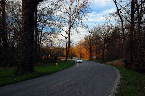
 One of the last scenic roads leading into Cape Girardeau is Bloomfield Rd. When I wrote about a spring alongside the road near Elmwood Apr. 2, 2010, and ran this photo, I wrote under it, “This view, by the way, is the reason Bloomfield Road SHOULDN’T be widened. There should be some roads left that let us appreciate what the area was like before it became paved over. If the road isn’t fast enough for you, then don’t move out there. Ditto Route W. OK, rant off.”
Public Meeting May 26
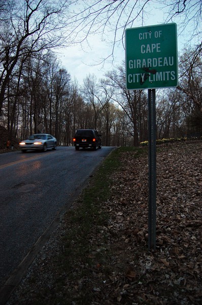 I happened to see this “Bloomfield Road Improvement Meeting May 26” announcement on the city’s website. Now, when I see something labeled “Improvement,” that’s a signal that it’s a done deal, even without the meeting.
For some of us, widening the road, increasing the speed limits and cutting down the canopy of trees that makes Bloomfield Road special isn’t an “improvement.”
Here’s the full announcement:
Phases 4 and 5 of the Bloomfield Road Improvement Project will be discussed during a public meeting on Thursday, May 26 at 6:30 p.m., at the Osage Centre.
Information will be provided regarding traffic control during phase 4. Affected areas include Bloomfield Road between Stonebridge Drive to just south of the Benton Hill Road intersection. Phase 4 construction is slated to begin mid-June, with utility relocation occurring prior.
Citizen input is requested regarding phase 5, which includes Bloomfield Road west of the Benton Hill Road intersection to White Oaks Lane.
How long before it is Mount Auburnized?
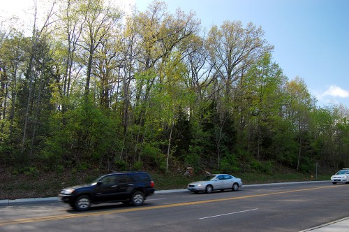 When Mount Auburn Road was proposed to link Hopper and Gordonville Roads in 1961, it was billed as “scenic route west of Cape.” Before long, it turned into a four-lane expressway that gobbled up the front yards of the homes along it.
What happens to the Bloomfield Spring?
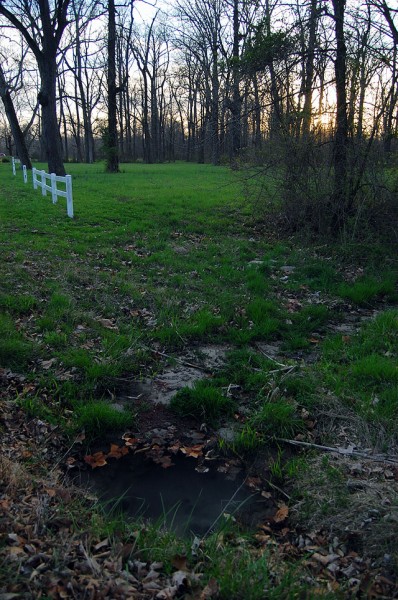 My great-great grandmother, my grandmother and my mother all stopped for water at this spring on their treks from Advance to Cape to go shopping. Some of those trips were made by wagon.
This spring, which refreshed travelers for more than a century is right off the roadway. Will it be lost to future generations?
How about the Elmwood Gates?
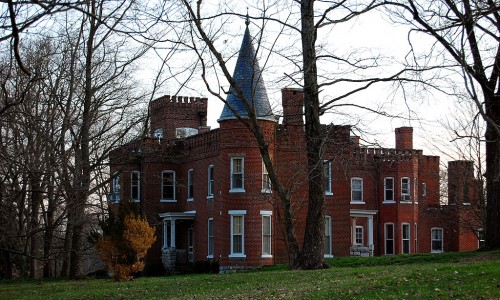 The old gates that guard the entrance to Elmwood aren’t far off the roadway. Will they get taken out this time or will they be around until the road is four-laned?
Where is Dennis Scivally?
When the first road in Cape County was paved in 1920 – the stretch of South Sprigg called Tollgate Hill – Dennis Scivally, the engineer in charge of the project said, “Several walnut trees had to be cut down, but care will be taken to cut down no trees not absolutely necessary to remove. It is the plan to retain the beauties of the road as well as make it good for traveling over. Along most of the distance are now growing beautiful trees. These will be cared for, underbrush and weeds will be removed, painted signs along the way will be tabooed, as well as signs tacked to trees.”
Where is our Dennis Scivally today?
What can we do?
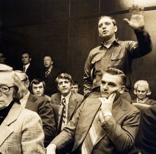 If I was in Cape, I’d show up at the meeting on May 26 at 6:30 p.m. at the Osage Center. I’m sure it’ll be an exercise in futility, but I’d feel better for having given it a try.
Just do me a favor: if and when they DO chop down the trees and destroy the spirit of the road forever, put in bike lanes. We might as well win SOMETHING out of it.

After the last big ruckus over the widening of Bloomfield Road, I can’t believe the plan is still in place.
We’ve even had meetings about this issue in Stoddard county. Our Stoddard County Historical Society invited Southeast Missourian webmaster and Pavement Ends blogger James Bond to give a presentation on the old road. It has historical significance for all of Southeast Missouri.
The Cape to Bloomfield Road was an important route for early pioneers who traveled south on Crowley’s Ridge down to Arkansas. In fact, it was the only way to avoid the swamplands (evident in this flood year).
These days, many people travel the road to see the beautiful fall foliage and appreciate the relaxed atmosphere under the arching trees.
I thought that one reason for the new shortcut on Nash Road was to take pressure off Bloomfield Road. Once the Nash Road improvement is complete, a huge amount of the southern traffic to Cape will be diverted directly to I-55.
Why widen Bloomfield Road for the bustling business traffic which will no longer need it?
I hope this heartless decision is reconsidered.
Ken, do you mind if I put a link to this story on my Dexter Daily Statesman blog?
Madeline,
You’re welcome to hire a skywriter and put the link in the air if it’ll preserve Bloomfield Road.
Not sure of plans now, but when I was on the Council there were plans to include a hiking/bike trail parallel with the roadway. One of the significant landowners along the project had worked with the staff to retain as many trees as possible and to retain as much character as possible along the route.
Ah, progress….
Let’s all join in for a chorus of Big Yellow Taxi:
“They took all the trees, and put em in a tree museum
And they charged the people a dollar and a half to see them
No, no, no
Don’t it always seem to go
That you don’t know what you got ’til it’s gone
They paved paradise, and put up a parking lot”
My Mother and her sisters walked Bloomfield road to go to the old Campster School
Government 101 – spend everything allocated. With a steady stream of funds through Cape’s nifty sales tax mechanism, the engineering department will find projects for it all, especially those with strong political support. Let’s check the map and see what is located on Bloomfield Road that may identify these folks.
It would not only be sad but very stupid for this to occur. I remember very vivid traveling Bloomfield Road to see all the beautiful scenery as our family traveled to my Grandma who lived in Allenville. The trees and streams. It was and still is a peaceful and serene sight. Leave it as it is. Not EVERYTHING has to be destroyed for progress!
I’ll put my council hat on – even though I am no longer on (term limits). The Bloomfield Road corridor improvements were/are part of TTF3 and TTF4. Planning & Zoning spends 1-2 years on project list(s) prior to a vote by the citizens of Cape Girardeau. P&Z holds open meetings and hearings during the process. City Staff/Engineers/Planning Division faciliate. The council receives updates during the process. When P&Z is ready, they provide the council with a draft list of potential projects (in no order of priority). The Council then holds study sessions to review/change/revise. Once the list is final, it is put on the agenda where public input is welcome before the ordinance is approved to place on a ballot.
I apologize for the civics lesson. But many times people wait till its too late to voice their opinion or are not familiar with the process. During my terms on the council, it was interesting how many people “outside of the city” would weigh in on a particular issue or concern. I think that is a good thing because they do lay a claim to Cape Giradeau as their home base for work/shopping/leisure and are interested.
During this process, P&Z and the council have strived to attain a balance of improvement (via TTF) in all parts of the city. Being part of this process for TTF 3 & 4, I do not believe decisions were made by who happened to live or own property along a particular street. The local media has always done an appropriate job of printing the information in the paper to advise citizens of the progress.
Cape Girardeau citizens should be proud of the manner in which the TTF projects have been carried out because all money collected has gone directly to those projects and not supplanted like other projects around our state.
I will too miss the Sunday afternoon drives along the blacktop canopy. But as I mentiond above, there should be a some character left with the new pavement.
http://www.cityofcapegirardeau.org/ttf4.aspx
I’ll have to put my Cape Girardeau hat on – even though I live 1,100 miles away.
Thanks for the feedback. The shame of it is that a civics lesson IS needed from time to time.
Having been to a zillion public meetings in almost half a century of recording them, I am well aware that most citizens are too busy working for a living or watching American Idol to pay much attention to the workings of city government until they hear the chain saws and bulldozers.
I admit to being a carpetbagging outsider who lives 1,100 miles away, like I mentioned, but I’ve driven and appreciated that road on the many trips I’ve made down it. I pointed out that at least three generations of my family have traveled on it, going back to horse and buggy days. (Actually, that would be six generations, spanning from my great-great-grandparents through my grandson.)
I’m using my little platform to make my readers aware that there is a public meeting and, while it may be too late, they should show up if they want to have a voice in the process.
If the road is “improved,” the first step will be to widen it; that will increase the speed of traffic and increase its volume. That, of course, will necessitate taking the second step: widening it again to accommodate all that new traffic.
I’m sure the new road will have “some character left.” Maybe we can put up historical markers that say, “There used to be a tree here” or “Under this slab used to be a spring where thirsty travelers would refresh themselves.”
Charlie, am I reading the map correctly? Is it really only one mile of Bloomfield Road that is being widened?
That is what has everyone in a tizzy? Going 35 mph, that’s just one minute and 42 seconds.
Cheers,
Matt
Here’s the tizzy:
1. Widening a road leads to more road widening. The argument will be made that the “narrow” portion is acting as a choke point and will cause accidents because cars will have to slow down.
2. The widening will take it up to the intersection of Benton road, described as “It is all in woods and is part of the most scenic crossroads site in this entire area. Trees leading to the intersection of the two roads form a bower over the road, giving it deep shade and an idyllic appearance to the motorist. Even on the hottest of days the drive through the intersection is cool, adding to the physical beauty of the spot.”
Read more about Mount Tabor Park, another landmark on Bloomfield Road that’s gone.
Way To go Ken. Give them Hell.
There’s an oldtimer on a touring cyclist email list I’m on who used the phrase, “I took a crap so big it made my hat fit better.”
Ranting against a project that I’m told is 98% approved may make my hat feel better, but I don’t think it’ll make any difference in the long run.
I’ve been told that the next phase won’t be as wide as the section down by Campster School, but I’m still afraid that’s wide enough. And, like I said, “pave it and they will come.”
I hope some of you can make it to the meeting, but I wouldn’t get my hopes up that you’ll accomplish anything except, maybe, make your hat fit better.
Ken,
My grandfather first drove me out that road, identifying it as a “true country road”, further noting that you couldn’t really find them anymore.
Aren’t there some notably posh homes out there now, and wouldn’t it seem that the owners might have specifically chosen to live in that very special setting?
As a de facto Ken Burns of Cape Girardeau history, culture, and environs, you have every single right to speak out for something you believe in.
Steve Carosello
The Ken Burns of Cape Girardeau?
What with the river going down, I thought it would be safe to put away my hip waders
Cheers,
Matt
Hey, kid,
When you’re not making any money, you have to take your pay in love.
I’ll accept compliments.
Everyone who can, PLEASE come to the meeting. Maybe a niracle will happen. Maybe not but come and let them know how you feel about destroying the scenic and cool in summer Bloomfield Road.
Cape once had a farsighted mayor that advocated a road from Blomeyer connecting to Nash Road to lessen traffic on Bloomfield Road. He was ignored and a new bridge and highway over the diversion channel to nowhere when it floods was built. That was state $.
Now I understand the roundabout will be connected to Nash road via a new road. That is state $.
That in my opinion should give cause to rethink the Bloomfield Road project since a lot of traffic from Chaffee-Delta directions will choose the Nash Road route. Save the city $ and the trees.
I’ve spent all of one day in Cape Girardeau so that gives me a right to spout off, right?
I’ve been in many meetings (school, church, whatever) where objections are raised to a proposal. Then somebody on the “pro-” side says, “These people worked hard and put in a lot of hours to come up with this plan.” Instead of arguing the merits, they try to lay a guilt trip on those objecting. I’ve been on both sides of that ploy–both in a chair in the audience and at the table in front of the room. I’ve decided I don’t like it either way.
We have these same sorts of issues in southwest Michigan every now and then. Some years back there was a proposal to repave and widen 40th street near my workplace. It was a nice street, lined with huge sugar maples on each side. The road commission types said they had to do it that way. In order to get federal funds, it had to be a class A road, and in order to be a Class A road it had to be cleared X feet on either side. I don’t remember what number X was. But citizens kept up their objections. It happened to be a road where people cared a lot and were willing to put in a lot of work to fight the “improvements”. In the end it was decided that maybe it could still be a Class A road without taking all of those maple trees down. X was changed to some smaller number. The road now isn’t as pretty as it used to be, but it’s not too bad. And there is now a paved shoulder that makes it nicer for bicycling — not that it was unbicycleable before that.
These days, a lot is lost for the sake of safety and efficiency.
John,
You rode a bicycle from Michigan to be able to experience Cape, so that gives you some street cred.
Thanks for weighing in.
As a youngster, I have fond summer memories of walking the Bloomfield road, from our home in Rodney Vista, to the Potashnick offices on Highway 74 at the other end. This just to catch a ride back home with my dad. The “BloomField Spring” was the perfect place to stop along the four or five mile hike and recharge my RC soda bottle and wash down a moon pie.
Every drive I take on that lovely road evokes those memories. What a shame to remodel that little piece of nostalgia.
My wife is from Cape, and I’ve driven Bloomfield many times, especially when we lived there. I always admired this beautiful section of Cape and it’s sad to see it somewhat come to an end.
Even though I live 400 miles away, some of my fondest memories of being in Cape was being under that cool canopy of trees. Being from West Virginia and marrying a flatlander, I take all the shade I can get while I’m out there. Y’all have no mountains to shield you from the sun. 😛
Nice job of saber rattling. Yes of course that stretch of road is a favorite of just about everyone who has lived in Cape Girardeau, but I suspect that everyone who likes or pines for it should go now and drive down that lane/road one more time before it is made wider.
In case you haven’t noticed, shade trees have been replaced by pickup trucks that come standard with air-conditioning…
“Plan the town, if you like; but in doing it do not forget that you have got to spread the people. Make wider roads, but DO NOT narrow the tenements behind. Dignify the city by all means, but NOT at the expense of the health of the home and the family life and the comfort of the average workman and citizen.” – Thomas Adams
Unfortunately, pickup trucks nowadays do not come with common sense as a standard feature.
@Matt:
You must remain ever-vigilant.
Let down your guard at your own peril.
Bloomfield Road, I’m told, was the long ago staging site of the nefarious plot to lynch a mannequin on the I-55/Bloomfield Road overpass. Ever shall that idyllic road live in sweet, high school summer memory.
The idyllic nature of Bloomfield Road is mentioned in this piece on Doggett and Mount Tabor Parks.
A 1966 survey listed three scenic roads in Cape County: Bloomfield Road, Cape Rock Drive and the Ten Mile Garden between Cape and Jackson. The Ten Mile Garden and it’s canopy of trees was wiped out when Highway 61 was widened.
Now, we’re looking at doing the same to Bloomfield Road, if not this time, then the next time someone wants to pour concrete.
Many of us remember well the 10-Mile Rose Garden between Cape and Jackson. It could not be more glaringly obvious that there wasn’t the slightest thought given to retaining even one iota of its beauty.
I’m willing to give Highway 61 a pass. It was a major U.S. highway with no good alternate routes. The volume of traffic justified its widening.
What DOES turn my crank, though, was the loss of Wedekind Park, near the intersection of Hwy 61 and I-55.
The Missourian had a brief Jan. 19, 1961, that said the park and its small wooded area would be left undisturbed when the I-55 interchange was built nearby.
Wonder where the park went? It was lost in 1992 to provide a new entrance for the Missouri Veterans Home and “for future developments at the location.”
The “improvements,” which resulted in the loss of a historic wooded park, were financed by MidAmerica Hotels, Inc.
Dan Drury, vice president of operations for MidAmerica Hotels, was quoted as saying, “Overall, you will see a safer traffic area than you have ever seen before. Our property is there also. This will benefit both of us.”
MidAmerica Hotels owns property on all four corners at the I-55 intersection, The Missourian reported.
Reader response used words like “rape,” “outrage” and “criminal.”
I do have to agree. Living 2 hours away, and having no family left in town, I rarely make it back to Cape. As my daughter is starting at the local college this Fall, I did come back to town this Spring and was saddened to see Snake Hill gone. What? Where will all the cross country runners train? IMO, it has always been easy to get across town, so I never had any complaints about the roads, and I probably wouldn’t have voted for that transportation tax. When I see projects like this, that don’t seem to justify themselves given the volume of traffic and the destruction of landscape, I relate just a little less to that popular jingle in the late 70s: “Cape Girardeau, it’s hometown to me. It’s a wonderful place to be” yada yada. 🙂
I attended the “so called” public hearing last night. There were multiple tables set up to display aerial views of the road along with engineering renderings of the proposed “improvements”. People simply wandered about viewing the documents and talked among themselves. There were forms available to leave written comments. It seems the Bloomfield residents are quite unhappy with the issue of speeding and accidents. According to them, the solution is widening and straightening as is proposed. I say – bring me a wider, straighter road and I can drive even faster. Perhaps I am missing something here as I am not knowledgeable with the engineering aspects of roads, but I surely have watched the widening of roads bring on more speeding and heavier traffic. I cannot follow the logic being presented. There are various electronic traffic cameras being used these days. Perhaps cameras could be installed to catch the speeders and stick them with big fines. I have no idea if such a thing is an option, but it surely would be less costly than construction work. I have not touched on what this will do to the beauty of that area. I don’t know exactly how many trees will be removed, but the removal of even one of those trees is too many. Perhaps others reading this attended the meeting and can offer their thoughts. I gather this is basically a “done deal”. I assume the city council has to give a final vote, but am not sure. Let’s keep this topic going…………….
It’s a done deal.
The best we can hope for is to save the last part of the road – from Benton Road to 74. It’s going to be tough. Once a road is partially widened, the old safety argument will be trotted out to justify more widening. They’ll say it’s dangerous to have high speed (which the widening created) traffic be constricted by the narrower, older road.
Despite all the hoopla about the Strack Quarry as the intersection of Bloomfield Road being a bad neighbor, this road widening will destroy more of Cape County’s history and beauty than that hole in the ground ever did.
If you like the way Mount Auburn Road looks, you’ll love the new Bloomfield Road in a few years when it’s four-laned. Want to start a pool to bet when it’s going to happen?
Sorry if I’m not reading closely enough to answer my own question, but, what is the opinion of those who actually live along this stretch of Bloomfield Road? Do they find it dangerous? Do they welcome improvements?
This is a quote from a man who attended the public meeting and lives along Bloomfield Rd….I assume he liked the road enough to purchase a home in that area, but has apparently changed his mind……quote from SE Missourian:
“I think it’s a great idea,” said Steve Griffith, who lives on nearby Winwood Drive. “There have been numerous accidents, and the road is way too narrow. The trees are beautiful, but that’s progress. And my wife and I are really excited about the trail.”
tis a shame that mom nature must accomodate the ever uglier cars and roadragenic’s, can’t even stop and smell the roses