 When we were driving past the castle called Elmwood, my mother wondered if a spring she remembered as a little girl was still there.
I had heard her talk about it years and years ago, so I thought I knew approximately where it was alongside Bloomfield Rd. I parked my van at Kensington Lane and walked north, back toward the curve in the road leading to Cape.
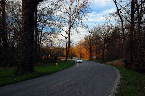
This view, by the way, is the reason Bloomfield Rd. SHOULDN’T be widened. There should be some roads left that let us appreciate what the area was like before it became paved over. If the road isn’t fast enough for you, then don’t move out there. Ditto Route W. OK, rant off.
Just south of the big tree that’s shown in the photo above and on the west side of the road, I saw a small rivulet of water running toward what used to be the Elmwood estate.
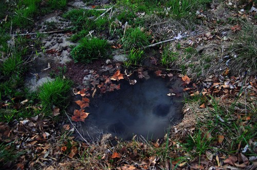
Water boils mark the spring
 I didn’t see a pipe running under the road that would account for the stream. When I looked at the pool through a polarizing filter on my camera, I could see beneath the reflections on the water’s surface.
Those black circles mark where water is boiling up out of the bottom of the pool.
I had found my Mother’s spring
“My Grandmother – my Mother’s Mother – Mary Adkins, would always buy some kind of pan at the dime store every time we came to Cape from Advance. On the way back, we’d stop at that spring and dip out a drink in the new pan. She died in 1938, when she was 75 years old, so that was quite a few years ago,” my mother, Mary Welch Steinhoff, recalled.
“I don’t remember what kind of car we had – it was before Model T days. Mother (Elsie Welch) would usually come along; Grandmother would drive. Dad (Roy Welch) never liked to drive.”
Did you stop for a drink on the way TO Cape?
“No, we didn’t have a pan on the way TO Cape.”
“Didn’t you ever think about bringing one along?” I asked?
“No, I guess she wanted a new pan and this was always an excuse to get one.”
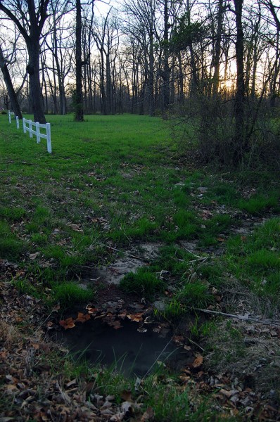
View of spring looking south
 That white fence marks what used to be the Elmwood property. I don’t know if this is in the 900 acres that were sold for the Dalhousie Golf Club or if it’s part of the 70 acres retained by the estate.
Map showing spring and Elmwood
View Bloomfield Spring & Elmwood in a larger map

If you build out where it’s pretty, they will come. Ken, you can speak against sprawl anytime. Put in a residential development, THEN argue for general taxpayer expense to widen the roads…and stormwater and sewer lines for yet more development. The developer invariably names streets, if not the subdivision itself, for things of nature to remind us of what once was the attraction. OK, my rant over.
I am so grateful for these articles about Elmwood, which I had hear about but knew nothing about. I do hobby genealogy so have my Gaither family back to Commerce, MO after having a Gaither Family reunion here in 2000. I did a lot of research about the early Gaither family who helped settle Commerce back when it was one of largest towns in this area.
Hettie Gaither, daughter of John Taylor Gaither,of Commerce married Herbert Hawthorn Ranney in 1883 and I believe connect to this bunch through Herbert’s mother Elizabeth Giboney.Do you have any information about this?
Catherine,
I have a confession to make. I’m not a historian. Well, I guess I sort of was, even though I never thought of myself that way.
I did history on horseback, where I’d grab a snippet of whatever was happening in front of me, see it translated to ink squirted on paper, which was thrown into a puddle in front of your house, to be used to housebreak your poodle.
Most of the historical info that appears in these posts is stolen from other historians on horseback who wrote for the local newspapers. Since I know how good I was, I always wonder how accurate any written account is.
I wish I could help, but I get lost in my own family tree once I get about three generations out. I admire folks who can get that stuff all sorted out.
I’m sorry I can’t be of more help. Maybe one of the readers has something to pass on.
For the first 6 years of my life my family lived on a farm southwest of Gordonville. In the early 1940’s my Mother,Father and children would make their weekly trip into Cape Girardeau, first to Shaul’s downtown to sell cans of separated cream, then “uptown” where my mother did her “trading” at Ruh’s Market, southwest corner of Good Hope and Frederick. I do remember on hot summer days, stopping at the spring pictured above, for a good, cold drink of water.
Question/request: Do you or a reader of your descriptions and viewers of your current or historical photos, have any info or pictures of the one-time restaurant/tavern that was located off Tollgate Hill (South Sprigg). SHADY GROVE establishment set north of the Seyer’s cattle barns etc and against the wooded area, some trees still remaining. Also the present Southern Expressway on-ramp to the north is now where the restaurant once was.
I was told yesterday by Don Seabaugh that the woods were the temporary home sites for some Smelterville residents during times of floods. He said the SHADY GROVE burned sometime in the 1940’s.
I took a picture of Tollgate Hill last week. I had heard of it – and Dad had talked about swiping watermelons when haulers had to slow down because of the grade – but never knew exactly where it was.
Mother pointed it out.
Shady Grove predates me by quite a bit. Fred Lynch and Sharon Sanders lurk around here. Maybe they have something in their files that will show up on Fred’s blog in The Missourian.
I worked a fatal house fire on the southwest corner of Sprigg and Giboney. Was it near there? That’s at the foot of the hill.
Thank you for this post! You will have settled a continuing argument by some Advance residents, one of whom INSISTED that the pond on Bloomfield Road was NOT the “spring” where her family stopped, when they went to Cape in the early 1900’s. I, arrogant soul that I am, insisted that it WAS. I’m happy to have the matter settled, even if it means I’m wrong!
I guess this road has been a popular topic among many residents of Southeast Mo., since we all heard of plans to widen it. Our Stoddard County Historical Society, which meets in Bloomfield, is keeping a close eye on the issue, as well.
Thanks for all you do, Ken! I agree about the history. Why is it that I love history but can’t stand geneology?? Too much detail.
Elizabeth Giboney was a descendant of the Giboney family that had Elmwood built.
There are springs all over out in the Bloomfield Road area. We have several on our land one of which runs so well that it becomes a creek.
The other comment I have is PLEASE help preserve this road and DO NOT support any effort to widen it. The speed limit has been changed to 35 mph and that is plenty fast for this road. The road is so beautiful with the trees lining it.
where can i get a map of the cape road–where did the trail of tears cross the road or is this road part of it-the john benge trail of tears that goes north of poplar bluff and down through fairdealing mo-they crossed the mississippi at belmont state park–thanks
I hope that any of you who are interested in preserving what will be left of the beautiful old Bloomfield Road will turn out when they have hearings on widening that last part of it and protest loudly.
The widening is already set up to the top of the hill by what used to be Mount Tabor Park where 206 and 205 meet. Apparantly we can’t change that now but hopefully we can preserve the rest of it along with the spring.
I figured it would be just a matter of time before one of the last really pretty drives close to Cape would be destroyed.
Mount Tabor should never have been given away and Bloomfield Rd. should be preserved, but speed and short-term expediency trumps all.
There are alternate routes for those who feel the need for speed.
Bloomfield Rd. and Elmwood hold many wonderful family memories for me and I would hope that the road would not be widened but left as it is so that the beauty of it can be enjoyed for generations to come!!!!!!!
yes the cape bloomfield road was the john benje trail of tears-which was the old shawnee trail what i can not find out is where they left the road to go south west they went south west at now day advance by natchitoches trail puxico to indian ford are went on down to bloomfield and went west across acorn ridge then on to indian ford at st francis river then on to kenner springs wich is now butler co–please e-mail any help about trail of tears we need road markers where the trail crossed the roads-thanks
Which King of Spain/ Elmwood Castle ?
Here is some more info on Elmwood.